Northeastern University station
Northeastern University station is a surface-level trolley stop on the MBTA Green Line. It is located in a dedicated median along Huntington Avenue in Boston, between Opera Place and Forsyth Street, and is adjacent to the Krentzman Quad on the campus of Northeastern University.| Tap on a place to explore it |
Photo: Pi.1415926535, CC BY-SA 4.0.
- Type: Railway stop
- Description: Light rail station in Boston, Massachusetts
- Also known as: “Northeastern”, “Northeastern station”, “NortheasternUniversity Libraries”, and “Opera Place station”
- Wheelchair access: yes
Places of Interest Nearby
Highlights include New England Conservatory of Music and Isabella Stewart Gardner Museum.
New England Conservatory of Music
College

Photo: Boston, Public domain.
The New England Conservatory of Music is a private music school in Boston, Massachusetts. The conservatory is located on Huntington Avenue along the Avenue of the Arts near Boston Symphony Hall, and is home to approximately 750 students pursuing undergraduate and graduate studies, and 1,500 more in its Preparatory School and School of Continuing Education. New England Conservatory of Music is situated 1,100 feet east of Northeastern University station.
Isabella Stewart Gardner Museum
Public building

Photo: Biruitorul, Public domain.
The Isabella Stewart Gardner Museum is an art museum in Boston, Massachusetts, which houses significant examples of European, Asian, and American art. Its collection includes paintings, sculpture, tapestries, and decorative arts. Isabella Stewart Gardner Museum is situated 2,600 feet west of Northeastern University station.
Matthews Arena
Stadium
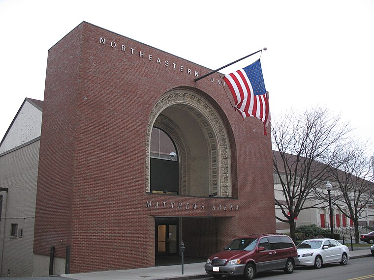
Photo: Nusportsinfo, CC BY-SA 3.0.
Matthews Arena is a historic multi-purpose arena in Boston, Massachusetts currently owned by Northeastern University. It is the world's oldest multi-purpose athletic building still in use, as well as the oldest arena in use for ice hockey. Matthews Arena is situated 1,500 feet east of Northeastern University station.
Places in the Area
Nearby places include Frederick Douglass Square Historic District and Fenway-Kenmore.
Frederick Douglass Square Historic District
Neighborhood

Photo: Tim Pierce, CC BY-SA 3.0.
The Frederick Douglass Square Historic District is a historic district roughly bounded by Hammond Street, Cabot Street, Windsor Street, and Westminster Street, in the Lower Roxbury area of Boston, Massachusetts.
Fenway-Kenmore

Photo: kenji ross, CC BY 2.0.
The Fenway-Kenmore neighborhood is named after Kenmore Square, and after the Fens, both of which it encompasses. Kenmore Square is the area's dynamic urban center.
Mission Hill
Suburb

Photo: MurderWatcher1, CC BY-SA 3.0.
Mission Hill is a 3⁄4 square mile, primarily residential neighborhood of Boston, bordered by Roxbury, Jamaica Plain and Fenway-Kenmore and the town of Brookline.
Northeastern University station
- Categories: tram stop, railway station, station, and transportation
- Location: City of Boston, Suffolk, Massachusetts, New England, United States, North America
- View on OpenStreetMap
Latitude
42.34005° or 42° 20′ 24″ northLongitude
-71.0897° or 71° 5′ 23″ westElevation
13 feet (4 metres)Network
MBTAOpen location code
87JC8WR6+24OpenStreetMap ID
node 7762578821OpenStreetMap feature
public_transport=stationOpenStreetMap feature
railway=haltOpenStreetMap attribute
wheelchair=yes
This page is based on OpenStreetMap, GeoNames, Wikidata, Wikimedia Commons, and Wikipedia.
We’d love your help improving our open data sources. Thank you for contributing.
Satellite Map
Discover Northeastern University station from above in high-definition satellite imagery.
In Other Languages
From Chinese to Spanish—“Northeastern University station” goes by many names.
- Chinese: “东北大学站”
- Chinese: “東北大學站”
- Chinese: “波士頓美術館站”
- Chinese: “波士顿美术馆站”
- French: “Northeastern University”
- Spanish: “Northeastern (Metro de Boston)”
- Spanish: “Universidad Northeastern (Metro de Boston)”
- Spanish: “Universidad Northeastern”
Localities in the Area
Explore places such as Frederick Douglass Square Historic District and Fenway.
Nearby Places
Explore places such as Anna’s Taqueria and Huntington Ave @ Opera Pl.
Massachusetts: Must-Visit Destinations
Delve into Boston, Cambridge, Springfield, and Worcester.
Curious Places to Discover
Uncover intriguing places from every corner of the globe.
About Mapcarta. Data © OpenStreetMap contributors and available under the Open Database License". Text is available under the CC BY-SA 4.0 license, except for photos, directions, and the map. Description text is based on the Wikipedia page “Northeastern University station”. Photo: Pi.1415926535, CC BY-SA 4.0.