Ambridge
Ambridge is a borough in Beaver County, Pennsylvania, United States. Incorporated in 1905 as a company town by the American Bridge Company, Ambridge is located 16 miles northwest of Pittsburgh along the Ohio River. The population was 6,972 at the 2020 census.| Tap on a place to explore it |
Photo: Leepaxton, CC BY-SA 4.0.
- Type: Town with 7,220 residents
- Description: borough in Beaver County, Pennsylvania, United States of America
- Also known as: “Ambridge, PA” and “Ambridge, Pennsylvania”
- Postal code: 15003
Places of Interest
Highlights include Ambridge Area High School and Ambridge–Aliquippa Bridge.
Ambridge Area High School
School
Ambridge High School is a midsized, suburban secondary school in Ambridge, Pennsylvania. By 2016, the school enrollment was reported as 749 pupils in grades 9th through 12th.
Ambridge–Aliquippa Bridge
Bridge
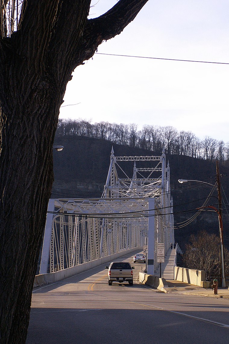 The Ambridge–Aliquippa Bridge is a steel cantilever through truss bridge which crosses the Ohio River at Ambridge, Pennsylvania. The bridge was originally named the Ambridge-Woodlawn Bridge but was soon renamed Ambridge-Aliquippa when Woodlawn was eclipsed by the rapid expansion of the Aliquippa Works of the Jones & Laughlin Steel Company.
Hopewell High School
School
Hopewell High School is a public high school in Hopewell Township, Pennsylvania, United States. It is the only high school in the Hopewell Area School District.
Places in the Area
Nearby places include Hopewell Township and Crescent Township.
Hopewell Township
Town
 Hopewell Township is a township in Beaver County, Pennsylvania, United States. The population was 13,506 at the 2020 census. It surrounds the city of Aliquippa and shares the city's ZIP Code. Hopewell Township is part of the Pittsburgh metropolitan area. Hopewell Township is situated 2 miles west of Ambridge.
Crescent Township
Village

Photo: Nyttend, Public domain.
Crescent Township is a township in Allegheny County, Pennsylvania, United States, and is part of the Pittsburgh Metro Area. The population was 2,479 at the 2020 census. Crescent Township is situated 2 miles south of Ambridge.
Byersdale
Hamlet
Byersdale is an unincorporated community in Harmony Township, Pennsylvania, United States. The community is located in Beaver County along Pennsylvania Route 65, directly north of the confluence of the Ohio River and Legionville Run and directly south of Baden. Byersdale is situated 2½ miles north of Ambridge.
Ambridge
- Categories: borough of Pennsylvania and locality
- Location: Borough of Ambridge, Beaver County, Pennsylvania, Mid-Atlantic, United States, North America
- View on OpenStreetMap
Latitude
40.58644° or 40° 35′ 11″ northLongitude
-80.22736° or 80° 13′ 39″ westPopulation
7,220Elevation
771 feet (235 metres)United Nations Location Code
US UBFOpen location code
86GXHQPF+H3OpenStreetMap ID
node 153896242OpenStreetMap feature
place=town
This page is based on OpenStreetMap, GeoNames, Wikidata, Wikimedia Commons, and Wikipedia.
We’d love your help improving our open data sources. Thank you for contributing.
Satellite Map
Discover Ambridge from above in high-definition satellite imagery.
In Other Languages
From Arabic to Welsh—“Ambridge” goes by many names.
- Arabic: “أمبريدج”
- Basque: “Ambridge”
- Catalan: “Ambridge”
- Cebuano: “Ambridge”
- Chechen: “Эмбридж”
- Chinese: “Ambridge”
- Chinese: “安布里奇市”
- Dagbani: “Ambridge”
- Dutch: “Ambridge”
- French: “Ambridge”
- German: “Ambridge”
- Gilaki: “امبریج (پنسيلوانيا)”
- Gilaki: “امبریج”
- Haitian: “Ambridge, Pennsilvani”
- Haitian: “Ambridge”
- Italian: “Ambridge”
- Japanese: “アンブリッジ (ペンシルバニア州)”
- Ladin: “Ambridge”
- Lithuanian: “Embridžas”
- Malagasy: “Ambridge, Pennsylvania”
- Malagasy: “Ambridge”
- Min Nan Chinese: “Ambridge”
- Persian: “امبریج، پنسیلوانیا”
- Persian: “امبریج”
- Portuguese: “Ambridge”
- Serbian: “Ambridge”
- Serbian: “Амбриџ”
- Serbo-Croatian: “Ambridge, Pennsylvania”
- Serbo-Croatian: “Ambridge”
- South Azerbaijani: “آمبریدج، پنسیلوانیا”
- Spanish: “Ambridge (Pensilvania)”
- Spanish: “Ambridge”
- Tatar: “Эмбридж”
- Turkish: “Ambridge, Pensilvanya”
- Turkish: “Ambridge”
- Ukrainian: “Ембридж”
- Uzbek: “Ambridge”
- Uzbek: “Амбридге”
- Vietnamese: “Ambridge, Pennsylvania”
- Vietnamese: “Ambridge”
- Volapük: “Ambridge”
- Welsh: “Ambridge, Pennsylvania”
- Welsh: “Ambridge”
Places with the Same Name
Discover other places named “Ambridge”.
Localities in the Area
Explore places such as Fairoaks and Ambridge Heights.
Notable Places Nearby
Highlights include Beaver Valley Tang Soo Do Academy and Reach for the Stars Dance Studio.
Pennsylvania: Must-Visit Destinations
Delve into Philadelphia, Pittsburgh, Harrisburg, and Scranton.
Curious Places to Discover
Uncover intriguing places from every corner of the globe.
About Mapcarta. Data © OpenStreetMap contributors and available under the Open Database License". Text is available under the CC BY-SA 4.0 license, except for photos, directions, and the map. Description text is based on the Wikipedia page “Ambridge”. Photo: Leepaxton, CC BY-SA 4.0.