University of Kansas - Lawrence Campus Gertrude Sellards Pearson Residence Hall
University of Kansas - Lawrence Campus Gertrude Sellards Pearson Residence Hall is a dormitory in City of Lawrence, Douglas County, Kansas which is located on West 11th Street. University of Kansas - Lawrence Campus Gertrude Sellards Pearson Residence Hall is situated nearby to David Booth Kansas Memorial Stadium, as well as near Elizabeth M. Watkins Community Museum.| Tap on a place to explore it |
- Type: Dormitory
- Also known as: “Gertrude Sellards Pearson Residence Hall” and “GSP Hall”
- Address: 500 West 11th Street, Lawrence, KS 66045
Places of Interest Nearby
Highlights include Elizabeth M. Watkins Community Museum and Spencer Museum of Art.
Elizabeth M. Watkins Community Museum
Museum

Photo: Bhall87, CC BY-SA 3.0.
The Watkins Museum of History is a museum in Lawrence, Kansas that is managed by the Douglas County Historical Society. It provides programs and public events, educational resources and activities, and changing exhibits about the heritage of Douglas County. Elizabeth M. Watkins Community Museum is situated 1,600 feet east of University of Kansas - Lawrence Campus Gertrude Sellards Pearson Residence Hall.
Spencer Museum of Art
Museum

Photo: Alan Islas, CC BY-SA 4.0.
The Spencer Museum of Art is an art museum operated by the University of Kansas in Lawrence, Kansas, United States. Spencer Museum of Art is situated 2,200 feet south of University of Kansas - Lawrence Campus Gertrude Sellards Pearson Residence Hall.
David Booth Kansas Memorial Stadium
Stadium
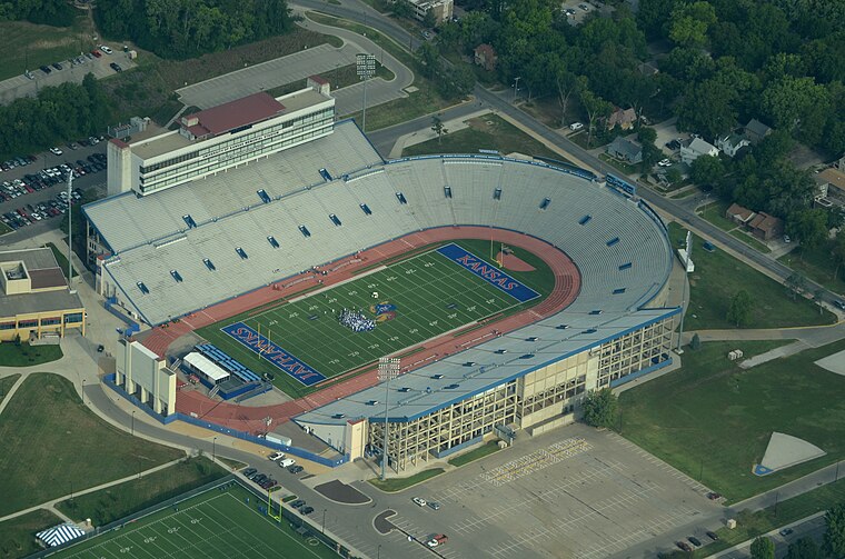
Photo: Ichabod, CC BY-SA 3.0.
David Booth Kansas Memorial Stadium or The Booth is a college football stadium in Lawrence, Kansas, on the campus of the University of Kansas. The original stadium was opened in 1921, and is the seventh oldest college football stadium in the country, and is widely recognized as the oldest west of the Mississippi River. David Booth Kansas Memorial Stadium is situated 1,600 feet southwest of University of Kansas - Lawrence Campus Gertrude Sellards Pearson Residence Hall.
Places in the Area
Nearby places include Lawrence and Midland.
Lawrence

Photo: Studio804, CC BY-SA 4.0.
Lawrence is a city in Eastern Kansas, USA along I-70, 35 miles west of Kansas City, Kansas. It is home to the University of Kansas. Lawrence provides a mix of academics, bohemia, and small-town Kansas kitsch.
Midland
Hamlet
Photo: Voidxor, CC BY-SA 4.0.
Midland is an unincorporated community in Douglas County, Kansas, United States. It is located two miles north of the city of Lawrence. Midland is situated 4½ miles north of University of Kansas - Lawrence Campus Gertrude Sellards Pearson Residence Hall.
Sibleyville
Hamlet
Sibleyville is an unincorporated community in Douglas County, Kansas, United States. It is located five miles southeast of Lawrence. It was at the intersection of County Road 458 and the Leavenworth, Lawrence and Fort Gibson railroad tracks although the town never had more than a dozen houses. Sibleyville is situated 6 miles southeast of University of Kansas - Lawrence Campus Gertrude Sellards Pearson Residence Hall.
University of Kansas - Lawrence Campus Gertrude Sellards Pearson Residence Hall
- Categories: building and residential building
- Location: City of Lawrence, Douglas County, Kansas, Great Plains, United States, North America
- View on OpenStreetMap
Latitude
38.96522° or 38° 57′ 55″ northLongitude
-95.24176° or 95° 14′ 30″ westElevation
965 feet (294 metres)Inception
1955Operator
University of KansasOpen location code
86C6XQ85+37OpenStreetMap ID
way 180851105OpenStreetMap feature
building=dormitoryGeoNames ID
7233790
This page is based on OpenStreetMap, GeoNames, Wikidata, and Wikimedia Commons.
We’d love your help improving our open data sources. Thank you for contributing.
Satellite Map
Discover University of Kansas - Lawrence Campus Gertrude Sellards Pearson Residence Hall from above in high-definition satellite imagery.
Localities in the Area
Explore places such as North Lawrence and Indian Hills.
Nearby Places
Explore places such as GSP & Corbin and University of Kansas - Lawrence Campus Corbin Residence Hall.
Kansas: Must-Visit Destinations
Delve into Topeka, Wichita, Kansas City, and Overland Park.
Curious Places to Discover
Uncover intriguing places from every corner of the globe.
About Mapcarta. Data © OpenStreetMap contributors and available under the Open Database License". Text is available under the CC BY-SA 4.0 license, except for photos, directions, and the map. Photo: Wikimedia, CC BY 2.0.