Marsaxlokk
Marsaxlokk is a small, traditional fishing village in the Southern Region of Malta. It has a harbour, and is a tourist attraction known for its views, fishing and history.| Tap on a place to explore it |
Photo: Seancarlgrech, CC BY-SA 3.0.
Photo: Felix Koenig, CC BY 3.0.
- Type: Village with 3,530 residents
- Description: village and port at the south of Malta
- Also known as: “M’Xloxx”, “Marsa Shlok”, and “Marsaxlok”
Places of Interest
Highlights include Għar Dalam and Fort Delimara.
Għar Dalam
Cave
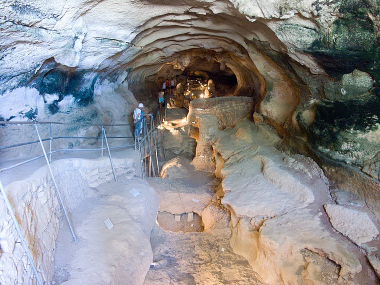
Photo: Jean-Christophe BENOIST, CC BY 2.5.
Għar Dalam is a 144-metre long phreatic tube and cave, located in the outskirts of Birżebbuġa, Malta. The cave contains the bones of animals that lived on Malta during the Pleistocene and Holocene epochs.
Fort Delimara

Photo: Wikimedia, CC BY-SA 3.0.
Fort Delimara is a polygonal fort in Marsaxlokk, Malta. It was built between 1876 and 1888 by the British as part of a chain of fortifications intended to protect Marsaxlokk Harbour.
Mamo Tower
Historic building

Photo: Wikimedia, CC BY-SA 3.0.
Mamo Tower, also known as San Tommaso Tower, is a fortified residence in Marsaskala, Malta. It was built by the Mamo family in 1657 on rising ground above St Thomas Bay on the east shore of Malta.
Places in the Area
Nearby places include Southern Harbor of Malta and Żabbar.
Southern Harbor of Malta

Photo: Tony Hisgett, CC BY-SA 4.0.
The Southern Harbour of Malta extends around the natural harbour between Valetta and the Three Cities, with numerous settlements, most of them dating back centuries, on rocks and cliffs immediately around the harbour bay, as well as further inland.
Żabbar
Photo: Tony Hisgett, CC BY-SA 4.0.
Żabbar, also known as Città Hompesch, is a city in the Port Region of Malta. It is the seventh largest city in the country, with an estimated population of 15,648 as of January 2021.
Cottonera

Photo: Dirk.heldmaier, CC BY-SA 3.0.
Cottonera is a group of three adjacent cities in Malta with a population of about 11,000 : Cospicua, Vittoriosa and Senglea. They are collectively also known as the Three Cities.
Marsaxlokk
- Category: locality
- Location: Malta Island, Malta, Europe
- View on OpenStreetMap
Latitude
35.8418° or 35° 50′ 30″ northLongitude
14.5448° or 14° 32′ 41″ eastPopulation
3,530Elevation
17 metres (56 feet)United Nations Location Code
MT MAROpen location code
8F7PRGRV+PWOpenStreetMap ID
node 265695880OpenStreetMap feature
place=village
This page is based on OpenStreetMap, GeoNames, Wikidata, Wikimedia Commons, and Wikipedia.
We’d love your help improving our open data sources. Thank you for contributing.
Satellite Map
Discover Marsaxlokk from above in high-definition satellite imagery.
In Other Languages
From Arabic to Vietnamese—“Marsaxlokk” goes by many names.
- Arabic: “مرسى شلوق”
- Armenian: “Մարսաշլոկ”
- Bashkir: “Марсашлокк”
- Basque: “Marsaxlokk”
- Bengali: “মারসাশ্লক”
- Catalan: “Marsaxlokk”
- Cebuano: “Marsaxlokk”
- Chinese: “马尔萨什洛克”
- Czech: “Marsaxlokk”
- Danish: “Marsaxlokk”
- Dutch: “Marsaxlokk”
- Esperanto: “Marsaxlokk”
- Finnish: “Marsaxlokk”
- French: “Marsaxlokk”
- German: “Marsaxlokk”
- Greek: “Μαρσαξλόκ”
- Greek: “Μαρσασλόκ”
- Greek: “Μάρσασλοκ”
- Greek: “Μαρσασλόκκ”
- Greek: “Μάρσασλόκκ”
- Gujarati: “માર્સાક્સલોક”
- Hebrew: “מרסשלוק”
- Hindi: “मार्सक्सलॉक”
- Hungarian: “Marsaxlokk”
- Indonesian: “Marsaxlokk”
- Italian: “Marsa Scirocco”
- Japanese: “マルサ・シロッコ”
- Japanese: “マルサシュロック”
- Japanese: “マルサシロク”
- Japanese: “マルサックスロック”
- Kannada: “ಮರಾಕ್ಸ್ಲೋಕ್”
- Kazakh: “Марсашлокк”
- Korean: “마르사실로크”
- Latin: “Herculis fanum”
- Latin: “Marsaxlokk”
- Latvian: “Marsašloka”
- Lithuanian: “Marsašlokas”
- Lombard: “Marsasloch”
- Malay: “Marsaxlokk”
- Maltese: “Marsaxlokk”
- Marathi: “मार्सक्सलोक”
- Norwegian Bokmål: “Marsaxlokk”
- Persian: “مارساکسلوک”
- Polish: “Marsaxlokk”
- Portuguese: “Marsaxlokk”
- Russian: “Марсашлокк”
- Sicilian: “Marsa Sciroccu”
- Sinhala: “මරසක්ස්ලෝක්ස්”
- Spanish: “Marsaxlokk”
- Swedish: “Marsaxlokk”
- Tamil: “மார்சஸ்ப்ளோக்க்”
- Telugu: “మార్కాక్స్లాక్”
- Thai: “มาร์ซักลอกก์”
- Turkish: “Marsaxlokk”
- Ukrainian: “Марсашлокк”
- Urdu: “مارساشلوک”
- Vietnamese: “Marsaxlokk”
Places with the Same Name
Discover other places named “Marsaxlokk”.
Localities in the Area
Explore places such as Ħal Ġinwi and Il-Qajjenza.
Malta Island: Must-Visit Destinations
Delve into Valletta, Mdina, Sliema, and St. Julian’s.
Explore These Curated Destinations
Discover places selected for their distinct character and enduring appeal.
About Mapcarta. Data © OpenStreetMap contributors and available under the Open Database License". Text is available under the CC BY-SA 4.0 license, except for photos, directions, and the map. Description text is based on the Wikipedia page “Marsaxlokk”. Photo: Felix Koenig, CC BY 3.0.