Quebrada de Misito
Quebrada de Misito is a stream in Imbabura, Ecuador and has an elevation of 2,017 metres. Quebrada de Misito is situated nearby to the locality Hacienda Iruminita, as well as near Hacienda Irumina.| Tap on a place to explore it |
Places in the Area
Nearby places include Ambuquí and Pimampiro Canton.
Ambuquí
Village
Ambuquí is a rural parish in northern Ecuador in the Imbabura Province. It is located in the Chota Valley 29 km away from Ibarra. The parish is also considered one of the major producers of the reddish yellow variety of the Spondias purpurea in the country. Ambuquí is situated 4 km north of Quebrada de Misito.
Pimampiro Canton
Town
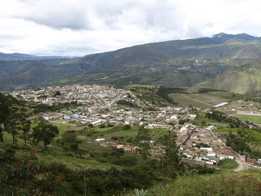
Photo: Estrada Pablo, CC BY-SA 4.0.
Pimampiro Canton is a canton of Ecuador, located in Imbabura Province. Its population in the 2001 census was 12,951 and 12,970 in the 2010 census. Pimampiro is located in the Andes of northern Ecuador. Pimampiro Canton is situated 9 km east of Quebrada de Misito.
Chota
Hamlet

Photo: amalavida.tv, CC BY-SA 2.0.
The upper valley of the Mira River, called the Chota River in its upstream portion, in northern Ecuador, and the small villages in it are usually referred to as 'El Chota', and it runs east–west between the two ranges of the Andes. Chota is situated 10 km northwest of Quebrada de Misito.
Quebrada de Misito
- Type: Stream
- Category: body of water
- Location: Imbabura, Ecuador, South America
- View on OpenStreetMap
Latitude
0.39755° or 0° 23′ 51″ northLongitude
-78.01942° or 78° 1′ 10″ westElevation
2,017 metres (6,617 feet)Open location code
67G39XXJ+26GeoNames ID
3654139
This page is based on GeoNames, Wikidata, and Wikimedia Commons.
We’d love your help improving our open data sources. Thank you for contributing.
Satellite Map
Discover Quebrada de Misito from above in high-definition satellite imagery.
Localities in the Area
Explore places such as Hacienda Iruminita and Hacienda Irumina.
Notable Places Nearby
Highlights include Quebrada Ayasquera and Quebrada Taruga Corral.
Ecuador: Must-Visit Destinations
Delve into Quito, Guayaquil, Chimborazo, and Cuenca.
Curious Streams to Discover
Uncover intriguing streams from every corner of the globe.
About Mapcarta. Text is available under the CC BY-SA 4.0 license, except for photos, directions, and the map. Photo: Wikimedia, CC0.