Maracanã
Maracanã is a railway stop in Rio de Janeiro, Grande Rio, Rio de Janeiro which is located on Avenida Presidente Castelo Branco. Maracanã is situated nearby to the railway station Mangueira station, as well as near the park Quinta da Boa Vista.| Tap on a place to explore it |
- Opening hours:
Monday—Friday: 4:25 AM—11:35 PM
Saturday: 5:55 AM—9:05 PM
Sunday: 5:55 AM—9:55 PM
public holidays: 5:50 AM—7:30 PM - Type: Railway stop
- Also known as: “Derby Club” and “Maracana”
- Address: Avenida Presidente Castelo Branco
- Wheelchair access: yes
Places of Interest Nearby
Highlights include Maracanã station and Mangueira station.
Maracanã station
Metro station

Photo: Wikimedia, CC BY 2.0 br.
Maracanã Station, formerly known as Derby Club Station, is a railway station in Maracanã, Rio de Janeiro which services the Maracanã Stadium. The station was inaugurated in July, 2014, and is serviced by the Rio de Janeiro Metro and SuperVia.
Mangueira station
Railway station

Photo: Junius, Public domain.
Mangueira is a railway station in Mangueira, Rio de Janeiro, which is serviced by the Supervia. Mangueira station is situated 350 metres west of Maracanã.
Quinta da Boa Vista
Park
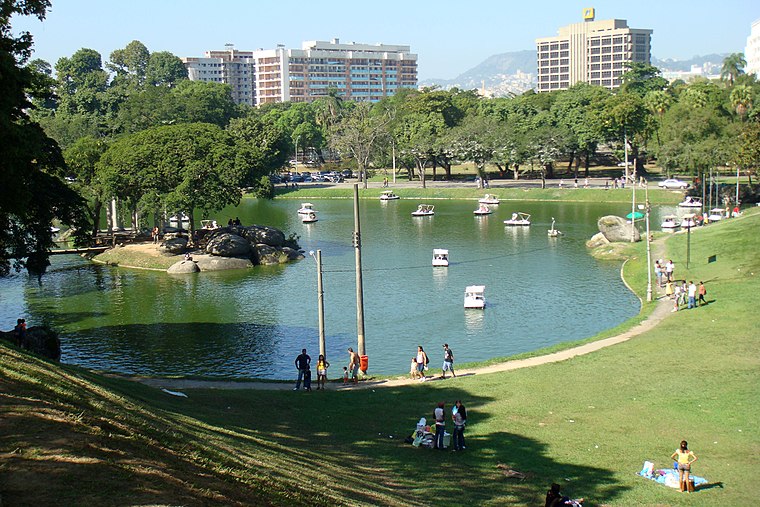
Photo: Halleypo, CC BY-SA 3.0.
The Quinta da Boa Vista is a public park of great historical importance located in the São Cristóvão neighbourhood, in the North zone of the city of Rio de Janeiro, Brazil. Quinta da Boa Vista is situated 1 km northeast of Maracanã.
Places in the Area
Nearby places include Mangueira and Maracanã.
Mangueira
Suburb

Photo: Drmarcelodavid, CC BY-SA 4.0.
Mangueira is a shantytown neighborhood in the city of Rio de Janeiro, Brazil, centered on the Mangueira hill or morro. It is most famous for its samba school, the Estação Primeira de Mangueira or simply Mangueira, which is one of strongest competitors in the annual Rio Carnival samba competition.
Maracanã
Suburb

Photo: Wikimedia, Public domain.
Maracanã is a middle-class neighborhood in the Northern Zone of Rio de Janeiro city. The Maracanã Stadium is located in this neighborhood, as well as the Ginásio do Maracanãzinho.
São Francisco Xavier
Suburb
São Francisco Xavier is a neighborhood in the North Zone of Rio de Janeiro, Brazil.
Maracanã
- Categories: transport stop and transportation
- Location: Rio de Janeiro, Grande Rio, Rio de Janeiro, Southeast, Brazil, South America
- View on OpenStreetMap
Latitude
-22.90936° or 22° 54′ 34″ southLongitude
-43.23353° or 43° 14′ 1″ westElevation
14 metres (46 feet)Inception
1885Operator
SuperViaOpen location code
589R3QR8+7HOpenStreetMap ID
node 6754229489OpenStreetMap feature
public_transport=stop_positionOpenStreetMap feature
railway=stopOpenStreetMap attribute
wheelchair=yesGeoNames ID
8355908
This page is based on OpenStreetMap, GeoNames, Wikidata, and Wikimedia Commons.
We’d love your help improving our open data sources. Thank you for contributing.
Satellite Map
Discover Maracanã from above in high-definition satellite imagery.
In Other Languages
“Maracanã” goes by many names.
- Portuguese: “Estação Maracanã”
- Portuguese: “Maracanã”
Places with the Same Name
Discover other places named “Maracanã”.
Localities in the Area
Explore places such as Mangueira and Olimpo Mangueirense.
Nearby Places
Explore places such as Maracanã and Maracanã.
Rio de Janeiro: Must-Visit Destinations
Delve into Zona Sul, Centro, Rio de Janeiro–Galeão International Airport, and Zona Norte.
Curious Places to Discover
Uncover intriguing places from every corner of the globe.
About Mapcarta. Data © OpenStreetMap contributors and available under the Open Database License". Text is available under the CC BY-SA 4.0 license, except for photos, directions, and the map. Photo: Wolfhardt, CC BY-SA 3.0.