Unterm Röderweg
Unterm Röderweg is a locality in Karben, Wetteraukreis, Hesse. Unterm Röderweg is situated nearby to the locality Am Röderweg, as well as near Über dem Kälberberg.| Tap on a place to explore it |
Places of Interest
Highlights include Naturschutzgebiet Ludwigsquelle and Degenfeldsches Schloss.
Naturschutzgebiet Ludwigsquelle
Nature reserve

Photo: Prolingheuer, CC BY-SA 4.0.
Naturschutzgebiet Ludwigsquelle is a nature reserve.
Degenfeldsches Schloss
Castle
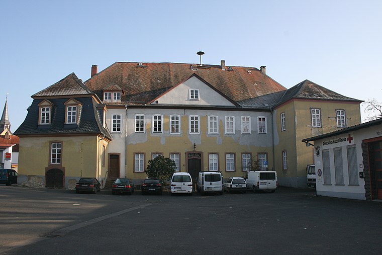
Photo: Haselburg-müller, CC BY-SA 3.0.
Degenfeldsches Schloss is a castle.
Evangelische Kirche Groß-Karben
Church

Photo: Gwador, Public domain.
Evangelische Kirche Groß-Karben is a church.
Places in the Area
Nearby places include Petterweil and Assenheim.
Petterweil
Village

Photo: MdE, CC BY-SA 3.0.
Petterweil is a village, which is situated 5 km west of Unterm Röderweg.
Assenheim
Village

Photo: Wikimedia, Public domain.
Assenheim is a village, which is situated 6 km north of Unterm Röderweg.
Erbstadt
Village

Photo: Gerold Rosenberg, CC BY-SA 3.0.
Erbstadt is a village, which is situated 6 km northeast of Unterm Röderweg.
Unterm Röderweg
- Type: Locality
- Location: Karben, Wetteraukreis, South Hesse, Hesse, Germany, Central Europe, Europe
- View on OpenStreetMap
Latitude
50.24894° or 50° 14′ 56″ northLongitude
8.78533° or 8° 47′ 7″ eastOpen location code
9F2C6QXP+H4OpenStreetMap ID
node 10054547306OpenStreetMap feature
place=locality
This page is based on OpenStreetMap, Wikidata, and Wikimedia Commons.
We’d love your help improving our open data sources. Thank you for contributing.
Satellite Map
Discover Unterm Röderweg from above in high-definition satellite imagery.
Localities in the Area
Explore places such as Am Röderweg and Über dem Kälberberg.
Notable Places Nearby
Highlights include Ludwigsbrunnen and Mehrzweckhalle Burg-Gräfenrode.
South Hesse: Must-Visit Destinations
Delve into Darmstadt, Bensheim, Lorsch, and Heppenheim.
Curious Localities to Discover
Uncover intriguing localities from every corner of the globe.
About Mapcarta. Data © OpenStreetMap contributors and available under the Open Database License". Text is available under the CC BY-SA 4.0 license, except for photos, directions, and the map. Photo: Mylius, GFDL.