Evergreen Avenue
Evergreen Avenue is a bus stop in County Roscommon, Connacht. Evergreen Avenue is situated nearby to the health club Smart Fitness Athlone, as well as near Monksland Community Center.| Tap on a place to explore it |
Places of Interest Nearby
Highlights include Athlone Castle and Luan Gallery.
Athlone Castle
Museum
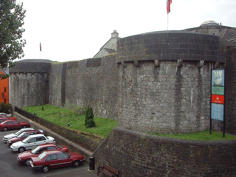
Photo: Sgbrito, Public domain.
Athlone Castle, sometimes known as Adamson Castle, is a castle located in Athlone, County Westmeath, Ireland, dating from the 12th century. Athlone Castle is situated 1½ km east of Evergreen Avenue.
Luan Gallery
Art gallery

Photo: Joseph Mischyshyn, CC BY-SA 2.0.
The Luan Gallery is a publicly owned art gallery in Athlone, County Westmeath, Ireland. The gallery opened in 2012, and the building consists of the older part, a former public library built in 1897 as a temperance hall, combined with a newer wing, designed by Keith Williams. Luan Gallery is situated 1½ km east of Evergreen Avenue.
Sean’s Bar
Pub

Photo: Serge Ottaviani, CC BY-SA 4.0.
Sean's Bar is a pub in Athlone, Ireland, notable for its reputed establishment in AD 900, and claim to being the oldest extant bar in Ireland. Architectural and archaeological records, including the Record of Monuments and Places and the National Inventory of Architectural Heritage, date the building to the 17th or 18th century. Sean’s Bar is situated 1½ km east of Evergreen Avenue.
Places in the Area
Nearby places include Athlone and Baylin.
Athlone

Photo: Imehling, CC BY-SA 3.0.
Athlone is a town in County Westmeath, almost dead-centre of Ireland and bisected by the River Shannon. The promenade on the River Shannon is popular among anglers, birdwatchers and swimmers.
Baylin
Village
Baylin, also written Bealin is a village in County Westmeath, Ireland, about 5 kilometres east of Athlone. Its postal address is Baylin, Athlone, County Westmeath, Ireland. Baylin is situated 8 km east of Evergreen Avenue.
Evergreen Avenue
- Type: Bus stop
- Category: transportation
- Location: County Roscommon, Connacht, West Ireland, Ireland, Britain and Ireland, Europe
- View on OpenStreetMap
Latitude
53.42425° or 53° 25′ 27″ northLongitude
-7.96716° or 7° 58′ 2″ westOpen location code
9C5JC2FM+P4OpenStreetMap ID
node 10098581617OpenStreetMap feature
highway=bus_stopOpenStreetMap feature
public_transport=platform
This page is based on OpenStreetMap, Wikidata, and Wikimedia Commons.
We’d love your help improving our open data sources. Thank you for contributing.
Satellite Map
Discover Evergreen Avenue from above in high-definition satellite imagery.
Notable Places Nearby
Highlights include Smart Fitness Athlone and Monksland Community Center.
Nearby Places
Explore places such as Abbeygarth and Center Point Autos.
Curious Bus Stops to Discover
Uncover intriguing bus stops from every corner of the globe.
About Mapcarta. Data © OpenStreetMap contributors and available under the Open Database License". Text is available under the CC BY-SA 4.0 license, except for photos, directions, and the map. Photo: Wikimedia, CC0.