Clínica Dental Titos
Clínica Dental Titos is a dental clinic in Granada, Granada, Andalusia. Clínica Dental Titos is situated nearby to the railway station Hípica, as well as near the marketplace Merca 80.| Tap on a place to explore it |
Places of Interest Nearby
Highlights include Alhambra and Nuevo Estadio de Los Cármenes.
Alhambra
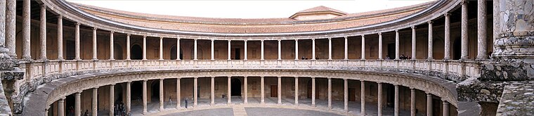
Photo: Bernd Untiedt, CC BY-SA 3.0.
The Alhambra is a palace and fortress complex located in Granada, Spain. It is one of the most famous monuments of Islamic architecture and one of the best-preserved palaces of the historic Islamic world. Alhambra is situated 2 km northeast of Clínica Dental Titos.
Nuevo Estadio de Los Cármenes
Stadium
Nuevo Estadio de Los Cármenes is a multi-use stadium in Granada, Spain. Currently, it is used mostly for football matches. The stadium has a capacity of 21,600 and was built in 1995 to be the home ground of Granada CF, the main football club of the city. Nuevo Estadio de Los Cármenes is situated 1 km south of Clínica Dental Titos.
Biblioteca Pública Municipal de Granada - Francisco Ayala
Library

Photo: JiriMatejicek, CC BY-SA 3.0.
Biblioteca Pública Municipal de Granada - Francisco Ayala is a library, which is situated 190 metres northeast of Clínica Dental Titos.
Places in the Area
Nearby places include Cruz de Lagos and Santa Juliana.


Albaicín
Quarter

Photo: Miguel303xm, CC BY-SA 2.5.
The Albaicín, also spelled Albayzín, is a neighbourhood of Granada, Spain. It is centered around a hill on the north side of the Darro River which passes through the city.
Clínica Dental Titos
- Type: Dental clinic
- Category: health care
- Location: Granada, Granada, Andalusia, Spain, Iberia, Europe
- View on OpenStreetMap
Latitude
37.16041° or 37° 9′ 38″ northLongitude
-3.59718° or 3° 35′ 50″ westOpen location code
8C9R5C63+54OpenStreetMap ID
node 10188201922OpenStreetMap feature
amenity=dentistOpenStreetMap feature
healthcare=dentist
This page is based on OpenStreetMap, Wikidata, and Wikimedia Commons.
We’d love your help improving our open data sources. Thank you for contributing.
Satellite Map
Discover Clínica Dental Titos from above in high-definition satellite imagery.
Notable Places Nearby
Highlights include Hípica and Merca 80.
Nearby Places
Explore places such as Peluquería Carlos González and Herbaes.
Granada: Must-Visit Destinations
Delve into Almuñécar, Alhama de Granada, Portugos, and La Alpujarra.
Curious Dental Clinics to Discover
Uncover intriguing dental clinics from every corner of the globe.
About Mapcarta. Data © OpenStreetMap contributors and available under the Open Database License". Text is available under the CC BY-SA 4.0 license, except for photos, directions, and the map. Photo: Ogre, Public domain.