Highgate Medical Clinic
Highgate Medical Clinic is a clinic in Burnaby, Metro Vancouver Regional District, British Columbia which is located on Kingsway. Highgate Medical Clinic is situated nearby to the government office Fraserhealth, as well as near the health club Club 16 Fitness Club.| Tap on a place to explore it |
- Opening hours:
Monday—Thursday: 10:00 AM—6:00 PM
Friday and Saturday: 10:00 AM—5:00 PM
public holidays and Sunday: 6:00 PM—6:30 PM - Type: Clinic
- Address: 103B, 7188 Kingsway
- Wheelchair access: yes
Places of Interest Nearby
Highlights include Edmonds station and Kingsway East School.
Edmonds station
Metro station
 Edmonds is an at-grade station on the Expo Line of Metro Vancouver's SkyTrain rapid transit system. The station is located southwest of the intersection of Griffiths Drive and 18th Avenue, near Edmonds Street, south of Kingsway in the Edmonds area of Burnaby, British Columbia. Edmonds station is situated 730 metres southwest of Highgate Medical Clinic.
Kingsway East School
School building

Photo: Xiao23, CC BY-SA 3.0.
Kingsway East School is a school building, which is situated 780 metres west of Highgate Medical Clinic.
Byrne Creek Community School
School
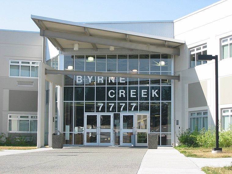
Photo: Wikimedia, CC BY-SA 3.0.
Byrne Creek Community School is a public high school in Burnaby, British Columbia and part of School District 41 in Burnaby. It is in the Edmonds area and serves over 1,000 students as of 2015. Byrne Creek Community School is situated 1¼ km south of Highgate Medical Clinic.
Places in the Area
Nearby places include Edmonds and Big Bend.
Edmonds
Neighborhood
Edmonds is a neighbourhood in the southeast of Burnaby, British Columbia, Canada. It is one of the city's four officially designated town centres. The area is served by the Expo Line of the SkyTrain via Edmonds station.
Big Bend
Neighborhood
Big Bend is the southernmost neighbourhood in Burnaby, British Columbia, Canada, located on the watershed of the Fraser River. The neighbourhood owes its name to the large bend that the river forms on its North Arm. Big Bend is situated 3 km southwest of Highgate Medical Clinic.
South Slope
Neighborhood
South Slope, sometimes referred to as Alta Vista, is a mainly single-family neighbourhood in Burnaby in British Columbia, Canada, just south of Metrotown. South Slope is situated 3½ km west of Highgate Medical Clinic.
Highgate Medical Clinic
- Category: health care
- Location: Burnaby, Metro Vancouver Regional District, British Columbia, Canada, North America
- View on OpenStreetMap
Latitude
49.21821° or 49° 13′ 6″ northLongitude
-122.95533° or 122° 57′ 19″ westOpen location code
84XV629V+7VOpenStreetMap ID
node 10296106347OpenStreetMap feature
amenity=clinicOpenStreetMap feature
healthcare=clinicOpenStreetMap attribute
wheelchair=yes
This page is based on OpenStreetMap, Wikidata, and Wikimedia Commons.
We’d love your help improving our open data sources. Thank you for contributing.
Satellite Map
Discover Highgate Medical Clinic from above in high-definition satellite imagery.
Notable Places Nearby
Highlights include Fraserhealth and Highgate.
Nearby Places
Explore places such as Mulberry Dental Clinic and Scotiabank.
British Columbia: Must-Visit Destinations
Delve into Vancouver, Victoria, North Vancouver, and City Centre.
Curious Clinics to Discover
Uncover intriguing clinics from every corner of the globe.
About Mapcarta. Data © OpenStreetMap contributors and available under the Open Database License". Text is available under the CC BY-SA 4.0 license, except for photos, directions, and the map. Photo: Kenny Louie, CC BY 2.0.