K.uno Jewelry
K.uno Jewelry is a jewelry shop in Naka Ward, Nagoya, Aichi. K.uno Jewelry is situated nearby to the electronics store Apple Store, as well as near the museum 橋本美術.| Tap on a place to explore it |
Places of Interest Nearby
Highlights include International Design Center Nagoya and Apple Store.
International Design Center Nagoya
Museum
The International Design Center NAGOYA and Design Museum, abbreviated as IdcN, is a museum and exhibition hall located in Sakae, Nagoya, central Japan. International Design Center Nagoya is situated 190 metres west of K.uno Jewelry.

Matsuzakaya
Department store

Photo: Renaik, CC BY-SA 4.0.
Matsuzakaya is a major Japanese department store chain operated by Daimaru Matsuzakaya Department Stores, a subsidiary of J. Front Retailing. When the chain was an independent company, Matsuzakaya Co, Ltd, it had its headquarters in Naka-ku, Nagoya. Matsuzakaya is situated 110 metres southeast of K.uno Jewelry.
Places in the Area
Nearby places include Nishiki 3-chome and Higashi.
Nishiki 3-chome
Neighborhood

Photo: Akahito Yamabe, CC BY-SA 4.0.
Nishiki 3-chome is a neighborhood.
Higashi
Suburb

Photo: Wikimedia, CC BY-SA 3.0.
Higashi Ward is one of the 16 wards of the city of Nagoya in Aichi Prefecture, Japan. As of 1 October 2011, the ward had an estimated population of 82,939 and a population density of 10,757 persons per km2. The total area was 7.71 km2.
Nagoya Castle
Locality
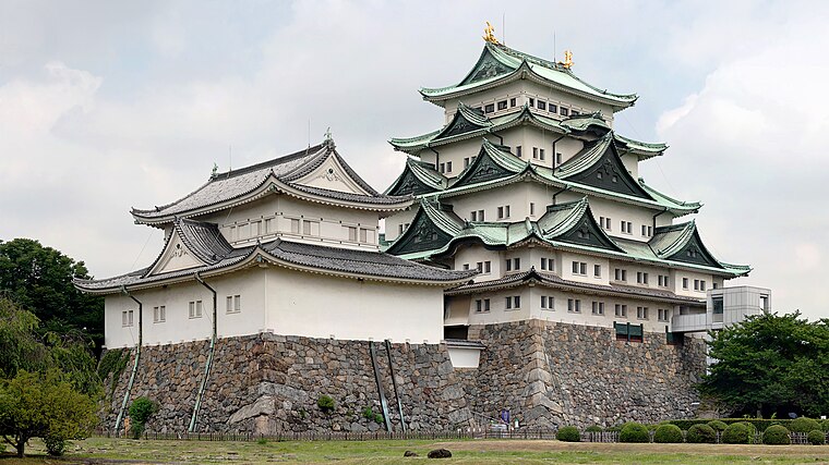
Photo: Base64, CC BY-SA 3.0.
Nagoya Castle is a Japanese castle located in Nagoya, Japan. Nagoya Castle was constructed by the Owari Domain in 1612 during the Edo period on the site of an earlier castle of the Oda clan in the Sengoku period.
K.uno Jewelry
- Type: Jewelry shop
- Wheelchair access: no
- Category: shop
- Location: Naka Ward, Nagoya, Aichi, Chubu, Japan, East Asia, Asia
- View on OpenStreetMap
Latitude
35.16524° or 35° 9′ 55″ northLongitude
136.90707° or 136° 54′ 26″ eastOpen location code
8Q7R5W84+3ROpenStreetMap ID
node 10556275711OpenStreetMap feature
shop=jewelryOpenStreetMap attribute
wheelchair=no
This page is based on OpenStreetMap, Wikidata, and Wikimedia Commons.
We’d love your help improving our open data sources. Thank you for contributing.
Satellite Map
Discover K.uno Jewelry from above in high-definition satellite imagery.
Notable Places Nearby
Highlights include 橋本美術 and Otsudori Denki Building.
Nearby Places
Explore places such as Yoshida and Able.
Aichi: Must-Visit Destinations
Delve into Toyota, Toyohashi, Okazaki, and Ichinomiya.
Curious Jewelry Shops to Discover
Uncover intriguing jewelry shops from every corner of the globe.
About Mapcarta. Data © OpenStreetMap contributors and available under the Open Database License". Text is available under the CC BY-SA 4.0 license, except for photos, directions, and the map. Photo: Wikimedia, CC BY 2.0.