Niggenberg
Niggenberg is a locality in Pfäfers, Sarganserland, Canton of St. Gallen. Niggenberg is situated nearby to the locality Schmiedberg, as well as near Siechrüti.| Tap on a place to explore it |
Places of Interest
Highlights include Wartenstein Castle and Pfäfers Abbey.
Wartenstein Castle

Photo: Parpan05, CC BY-SA 3.0.
Wartenstein Castle is a castle in the municipality of Pfäfers of the Canton of St. Gallen in Switzerland. It is a Swiss heritage site of national significance.
Pfäfers Abbey
Church

Photo: Ikiwaner, CC BY-SA 3.0.
Pfäfers Abbey, also known as St. Pirminsberg from its position on a mountain, was a Benedictine monastery in Pfäfers near Bad Ragaz, in the canton of St. Gallen, Switzerland.

Places in the Area
Nearby places include Pfäfers and Mastrils.
Pfäfers
Village

Photo: Roland Zumbuehl, CC BY-SA 3.0.
Pfäfers is a municipality in the Wahlkreis of Sarganserland in the canton of St. Gallen in Switzerland. The villages belonging to this municipality include: Pfäfers, St. Margrethenberg, Vadura, Valens, Vasön, and Vättis.
Mastrils
Village
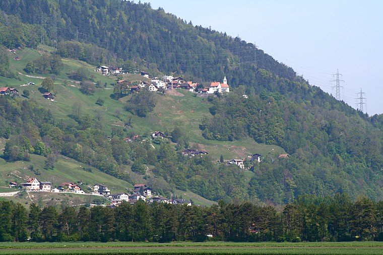
Photo: Parpan05, CC BY-SA 3.0.
Mastrils is a former municipality in the district of Landquart in the Swiss canton of Graubünden. The municipalities of Igis and Mastrils merged on 1 January 2012 into the new municipality of Landquart.
Maienfeld
Village

Photo: Parpan05, CC BY-SA 3.0.
Maienfeld is a municipality in the Landquart Region in the Swiss canton of the Grisons. It is a tourist destination in the Alps, both because of the local wine and because it was the setting of the story Heidi. Maienfeld is situated 2½ km north of Niggenberg.
Niggenberg
- Type: Locality
- Location: Pfäfers, Sarganserland, Canton of St. Gallen, Switzerland, Central Europe, Europe
- View on OpenStreetMap
Latitude
46.98471° or 46° 59′ 5″ northLongitude
9.52515° or 9° 31′ 31″ eastOpen location code
8FRFXGMG+V3OpenStreetMap ID
node 10731627423OpenStreetMap feature
place=locality
This page is based on OpenStreetMap, Wikidata, and Wikimedia Commons.
We’d love your help improving our open data sources. Thank you for contributing.
Satellite Map
Discover Niggenberg from above in high-definition satellite imagery.
Places with the Same Name
Discover other places named “Niggenberg”.
Localities in the Area
Explore places such as Schmiedberg and Siechrüti.
Notable Places Nearby
Highlights include Pro Natura Naturschutzgebiet Maienfelder Teiche and Möschriet.
Switzerland: Must-Visit Destinations
Delve into Zurich, Berne, Geneva, and Basel.
Curious Localities to Discover
Uncover intriguing localities from every corner of the globe.
About Mapcarta. Data © OpenStreetMap contributors and available under the Open Database License". Text is available under the CC BY-SA 4.0 license, except for photos, directions, and the map. Photo: EtschPat, CC BY-SA 4.0.