Praxis Dres. med. Seiler
Praxis Dres. med. Seiler is a doctor’s office in Regenstauf, Regensburg, Bavaria. Praxis Dres. med. Seiler is situated nearby to Lindenpark, as well as near the pitch Skaterpark Regenstauf.| Tap on a place to explore it |
Places of Interest Nearby
Highlights include Pfarrkirche St. Jakobus and Eichmühle.
Pfarrkirche St. Jakobus
Church

Photo: Gehsport-sepp, CC BY-SA 4.0.
Pfarrkirche St. Jakobus is a church, which is situated 1¼ km northwest of Praxis Dres. med. Seiler.
Eichmühle
Building
The Eichmühle is an old corn mill on the banks of the river Regen in the village of Regenstauf not far from the city of Regensburg in Bavaria, Germany. Eichmühle is situated 2 km northwest of Praxis Dres. med. Seiler.
Schloss Regendorf
Castle

Photo: Johanning, CC BY-SA 4.0.
Schloss Regendorf is a castle, which is situated 3½ km southwest of Praxis Dres. med. Seiler.
Places in the Area
Nearby places include Regendorf and Ramspau.
Regendorf
Village
Photo: Johanning, CC BY-SA 4.0.
Regendorf is a village, which is situated 3½ km southwest of Praxis Dres. med. Seiler.
Ramspau
Village
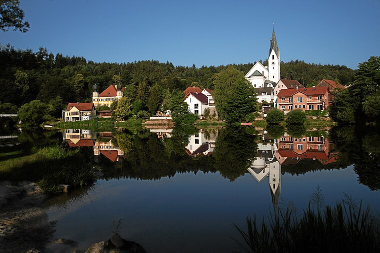
Photo: Mboesch, CC BY-SA 4.0.
Ramspau is a village, which is situated 5 km north of Praxis Dres. med. Seiler.
Karlstein (Regenstauf)
Village

Photo: Wikimedia, CC BY-SA 3.0.
Karlstein (Regenstauf) is a village, which is situated 5 km northeast of Praxis Dres. med. Seiler.
Praxis Dres. med. Seiler
- Type: Doctor’s office
- Category: health care
- Location: Regenstauf, Regensburg, Upper Palatinate, Bavaria, Germany, Central Europe, Europe
- View on OpenStreetMap
Latitude
49.11397° or 49° 6′ 50″ northLongitude
12.14003° or 12° 8′ 24″ eastOpen location code
8FXJ447R+H2OpenStreetMap ID
node 10755964966OpenStreetMap feature
amenity=doctorsOpenStreetMap feature
healthcare=doctor
This page is based on OpenStreetMap, Wikidata, and Wikimedia Commons.
We’d love your help improving our open data sources. Thank you for contributing.
Satellite Map
Discover Praxis Dres. med. Seiler from above in high-definition satellite imagery.
Notable Places Nearby
Highlights include Lindenpark and Bibliothek.
Nearby Places
Explore places such as Dialysezentrum Regenstauf and Ortho Docs Regenstauf.
Upper Palatinate: Must-Visit Destinations
Delve into Regensburg, Amberg, Cham, and Schwandorf.
Curious Doctor’s Offices to Discover
Uncover intriguing doctor’s offices from every corner of the globe.
About Mapcarta. Data © OpenStreetMap contributors and available under the Open Database License". Text is available under the CC BY-SA 4.0 license, except for photos, directions, and the map. Photo: Wikimedia, CC0.