APD Don Perkins Public Safety Center
APD Don Perkins Public Safety Center is a police station in Bernalillo, New Mexico which is located on Central Avenue Southwest. APD Don Perkins Public Safety Center is situated nearby to Rosenwald Building Historic Site, as well as near Museum of Albuquerque Library.| Tap on a place to explore it |
Places of Interest Nearby
Highlights include Rosenwald Building and S. H. Kress Building.
Rosenwald Building
Historic building
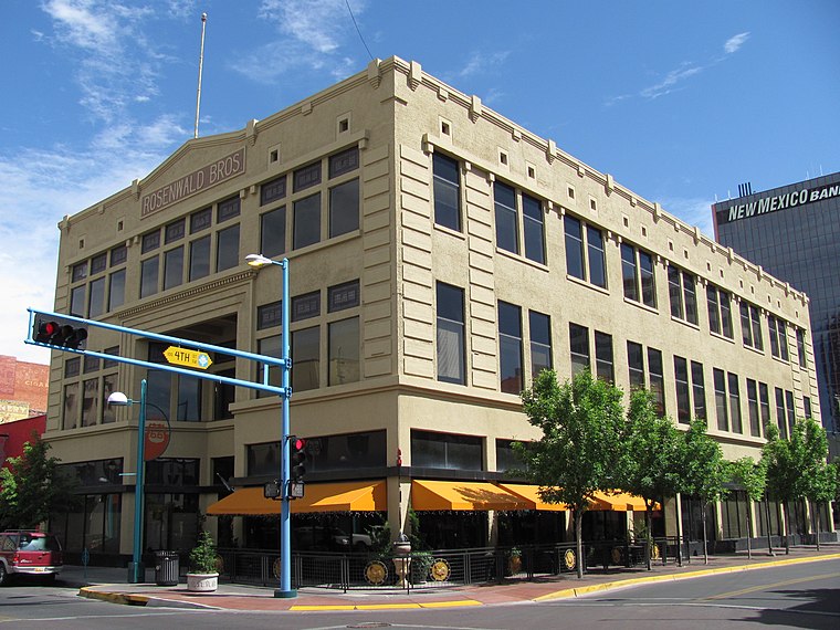 The Rosenwald Building is a historic building located in Downtown Albuquerque, New Mexico. Designed by Henry Trost of the El Paso firm of Trost & Trost and built in 1910, it was the first reinforced concrete building in the city.
S. H. Kress Building
Historic building
 The S. H. Kress Building is a historic commercial building in downtown Albuquerque, New Mexico. Built in 1925 by the S. H. Kress & Co. department store chain, it is notable as a well-preserved early 20th century retail building.
KiMo Theater
Historic building

Photo: Dschwen, CC BY-SA 4.0.
The KiMo Theatre is a theatre and historic landmark located in Albuquerque, New Mexico on the northeast corner of Central Avenue and Fifth Street. It was built in 1927 in the extravagant Pueblo Deco architecture, which is a blend of adobe-style Pueblo Revival… KiMo Theater is situated 400 feet northwest of APD Don Perkins Public Safety Center.
Places in the Area
Nearby places include Albuquerque and Martinez Town.
Albuquerque

Photo: Danae Hurst, CC BY 2.0.
Albuquerque, also known as ABQ, is a vibrant, sprawling city near the center of New Mexico. Cradled in the Rio Grande Valley beneath the Sandia Mountains, it is by far the largest city in the state, acting as the media, educational, and economic center of New Mexico, as well as the home of the state's only major airport, making it a common entry point into New Mexico.
Martinez Town
Neighborhood

Photo: Faolin42, CC BY-SA 3.0.
Martineztown-Santa Barbara is a neighborhood in central Albuquerque, New Mexico, immediately northeast of Downtown. Originating as a small farming village in the 1850s, it is one of the city's oldest neighborhoods and retains a distinct character, with winding streets, irregular lots, and adobe vernacular buildings reminiscent of other old Hispanic communities in northern New Mexico.
Silver Hill
Neighborhood

Photo: Wikimedia, CC BY-SA 4.0.
Silver Hill is a neighborhood in southeast Albuquerque, New Mexico, which is significant as one of the oldest developments on the city's East Mesa. Much of the neighborhood is included in the Silver Hill Historic District, which was listed on the National Register of Historic Places in 1986.
APD Don Perkins Public Safety Center
- Type: Police station
- Address: 320 Central Avenue Southwest, Albuquerque, NM 87102
- Location: Bernalillo, New Mexico, Southwest, United States, North America
- View on OpenStreetMap
Latitude
35.0844° or 35° 5′ 4″ northLongitude
-106.65138° or 106° 39′ 5″ westOperator
APDOpen location code
857M38MX+QCOpenStreetMap ID
node 10798850118OpenStreetMap feature
amenity=police
This page is based on OpenStreetMap, Wikidata, and Wikimedia Commons.
We’d love your help improving our open data sources. Thank you for contributing.
Satellite Map
Discover APD Don Perkins Public Safety Center from above in high-definition satellite imagery.
Notable Places Nearby
Highlights include Albuquerque on the Camino Real Historical Marker and Rosenwald Building Historic Site.
Nearby Places
Explore places such as Asia Noodle Bar and Access Inovations Incorporated.
New Mexico: Must-Visit Destinations
Delve into Albuquerque, Santa Fe, Las Cruces, and Roswell.
Curious Police Stations to Discover
Uncover intriguing police stations from every corner of the globe.
About Mapcarta. Data © OpenStreetMap contributors and available under the Open Database License". Text is available under the CC BY-SA 4.0 license, except for photos, directions, and the map. Photo: Dschwen, CC BY-SA 3.0.