Saint Peter’s Bell
Saint Peter’s Bell is a work of art in Cologne, Cologne Lowland, North Rhine-Westphalia. Saint Peter’s Bell is situated nearby to the historic site Ursulaportal, as well as near Petersportal.| Tap on a place to explore it |
- Type: Work of art
- Also known as: “St. Petersglocke”
- Wheelchair access: yes
Places of Interest Nearby
Highlights include Cologne Cathedral and Cologne Central Station.
Cologne Cathedral
Church

Photo: Der Wolf im Wald, CC BY-SA 3.0 de.
Cologne Cathedral is a cathedral in Cologne, North Rhine-Westphalia belonging to the Catholic Church. It is the seat of the Archbishop of Cologne and of the administration of the Archdiocese of Cologne.
Cologne Central Station
Railway station
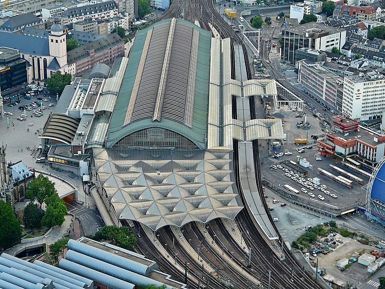
Photo: Neuwieser, CC BY-SA 2.0.
Köln Hauptbahnhof is the central railway station of Cologne, Germany. The station is an important local, national and international transport hub, with many ICE, Eurostar and Intercity trains calling there, as well as regional Regional-Express, RegionalBahn and local S-Bahn trains. Cologne Central Station is situated 230 metres northeast of Saint Peter’s Bell.
Museum Ludwig
Museum

Photo: Thomas Robbin, CC BY-SA 3.0.
Museum Ludwig, located in Cologne, Germany, houses a collection of modern art. It includes works from Pop Art, Abstract and Surrealism, and has one of the largest Picasso collections in Europe. It holds many works by Andy Warhol and Roy Lichtenstein. Museum Ludwig is situated 200 metres east of Saint Peter’s Bell.
Places in the Area
Nearby places include Deutz and Agnesviertel.
Deutz
Suburb

Photo: Tohma, CC BY-SA 4.0.
The Cologne borough of Deutz is a part of central Cologne, Germany, and was once an independent town known as Deutz am Rhein.

Belgian Quarter
Neighborhood

Photo: A.Savin, CC BY-SA 3.0.
The Belgian Quarter is an inner city district of Cologne, Germany. The name is derived from street names in the vicinity, referring to Belgian provinces or cities.
Saint Peter’s Bell
- Category: tourism
- Location: Cologne, Cologne District, Cologne Lowland, North Rhine-Westphalia, Germany, Central Europe, Europe
- View on OpenStreetMap
Latitude
50.94106° or 50° 56′ 28″ northLongitude
6.95721° or 6° 57′ 26″ eastOpen location code
9F28WXR4+CVOpenStreetMap ID
node 1094776315OpenStreetMap feature
tourism=artworkOpenStreetMap attribute
wheelchair=yes
This page is based on OpenStreetMap, Wikidata, and Wikimedia Commons.
We’d love your help improving our open data sources. Thank you for contributing.
Satellite Map
Discover Saint Peter’s Bell from above in high-definition satellite imagery.
In Other Languages
“Saint Peter’s Bell” goes by many names.
- Polish: “Dzwon Świętego Piotra”
Notable Places Nearby
Highlights include Ursulaportal and Petersportal.
Nearby Places
Explore places such as Südturm and Kölner Domshop.
Cologne Lowland: Must-Visit Destinations
Delve into Bonn, Leverkusen, Siegburg, and Bad Honnef.
Curious Work Of Arts to Discover
Uncover intriguing work of arts from every corner of the globe.
About Mapcarta. Data © OpenStreetMap contributors and available under the Open Database License". Text is available under the CC BY-SA 4.0 license, except for photos, directions, and the map. Photo: Ahgee, CC BY-SA 3.0.