alcaldia
alcaldia is a town hall in Rangel Municipality, Mérida. alcaldia is situated nearby to the public building Alcadia Rangel, as well as near the police station Comando de Policia.| Tap on a place to explore it |
Places in the Area
Nearby places include Mucuchíes and Apartaderos.
Mucuchíes
Town

Photo: Venex, CC BY-SA 3.0.
Mucuchíes is a town in the Rangel Municipality of Mérida State, Venezuela. It is at an altitude of 2,983 meters and has a cool climate, with an average temperature of 11 °C. The town was founded by Bartolomé Gil Naranjo in 1586.
Apartaderos
Town
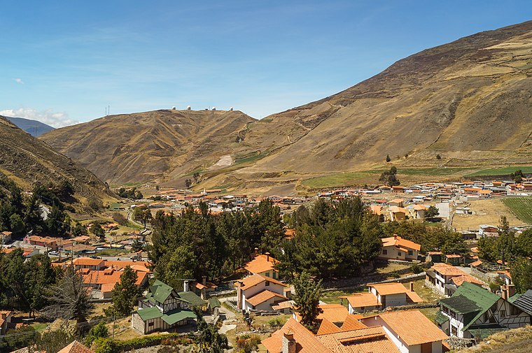
Photo: Rjcastillo, CC BY-SA 3.0.
Apartaderos is a small Andean town in Mérida State, Venezuela. Located at an altitude of 3,505 metres, it is the highest town in Venezuela, surrounded by páramo vegetation, the town has tourism facilities such as restaurants, gift shops and small hotels. Apartaderos is situated 9 km northeast of alcaldia.
alcaldia
- Type: Town hall
- Category: government building
- Location: Rangel Municipality, Mérida, Andes, Venezuela, South America
- View on OpenStreetMap
Latitude
8.74776° or 8° 44′ 52″ northLongitude
-70.92123° or 70° 55′ 16″ westOpen location code
67WFP3XH+4GOpenStreetMap ID
node 10963704413OpenStreetMap feature
amenity=townhall
This page is based on OpenStreetMap, Wikidata, and Wikimedia Commons.
We’d love your help improving our open data sources. Thank you for contributing.
Satellite Map
Discover alcaldia from above in high-definition satellite imagery.
Places with the Same Name
Discover other places named “alcaldia”.
Notable Places Nearby
Highlights include Alcadia Rangel and Comando de Policia.
Nearby Places
Explore places such as Hotel Los Conquistadores and Escuela Básica Artesanal de Mucuchíes.
Mérida: Must-Visit Destinations
Delve into Mérida, Santo Domingo, and El Vigía.
Curious Town Halls to Discover
Uncover intriguing town halls from every corner of the globe.
About Mapcarta. Data © OpenStreetMap contributors and available under the Open Database License". Text is available under the CC BY-SA 4.0 license, except for photos, directions, and the map. Photo: Wikimedia, CC0.