Liberty’s Symbols
Liberty’s Symbols is in Manhattan, New York. Liberty’s Symbols is situated nearby to Statue of Liberty, as well as near the garden 9/11 Memorial Grove.| Tap on a place to explore it |
Places of Interest Nearby
Highlights include Statue of Liberty and Ellis Island.
Statue of Liberty
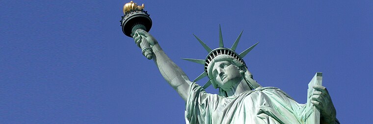 The Statue of Liberty is a colossal neoclassical sculpture on Liberty Island in New York Harbor, within New York City. The copper-clad statue, a gift to the United States from the people of France, was designed by French sculptor Frédéric Auguste Bartholdi and its metal framework was built by Gustave Eiffel.
Ellis Island
Islet

Photo: Wikimedia, Public domain.
Ellis Island is an island in New York Harbor, within the U.S. states of New Jersey and New York. Owned by the U.S. government, Ellis Island was once the busiest immigrant inspection and processing station in the United States.
Statue of Liberty Museum
Museum

Photo: Epicgenius, CC BY-SA 4.0.
The Statue of Liberty Museum is located on Liberty Island in New York City. The museum opened on May 16, 2019, and is focused on the creation, meaning, and history of the Statue of Liberty, a large statue by Frédéric Auguste Bartholdi which the people of France gave to the people of the United States in 1886. Statue of Liberty Museum is situated 1,000 feet northwest of Liberty’s Symbols.
Places in the Area
Nearby places include Communipaw and Red Hook.
Communipaw
Village

Photo: Semiautonomous, CC BY-SA 4.0.
Communipaw is a neighborhood in Jersey City in Hudson County, in the U.S. state of New Jersey. It is located west of Liberty State Park and east of Bergen Hill, and the site of one of the earliest European settlements in North America. Communipaw is situated 1½ miles northwest of Liberty’s Symbols.
Red Hook
Neighborhood

Photo: Jim.henderson, CC0.
Red Hook is a neighborhood in western Brooklyn, New York City, United States, within the area once known as South Brooklyn. It is located on a peninsula projecting into the Upper New York Bay and is bounded by the Gowanus Expressway and the Carroll Gardens neighborhood on the northeast, Gowanus Canal on the east, and the Upper New York Bay on the west and south. Red Hook is situated 2 miles southeast of Liberty’s Symbols.
Battery Park City
Neighborhood

Photo: Gryffindor, CC BY-SA 3.0.
Battery Park City is a mainly residential 92-acre planned community and neighborhood on the west side of the southern tip of the island of Manhattan in New York City. Battery Park City is situated 2 miles northeast of Liberty’s Symbols.
Liberty’s Symbols
- Type: Sign
- Categories: information and tourism
- Location: Manhattan, New York, Mid-Atlantic, United States, North America
- View on OpenStreetMap
Latitude
40.6887° or 40° 41′ 19″ northLongitude
-74.04392° or 74° 2′ 38″ westOperator
National Parks ServiceOpen location code
87G7MXQ4+FCOpenStreetMap ID
node 10966464534OpenStreetMap feature
tourism=information
This page is based on OpenStreetMap, Wikidata, and Wikimedia Commons.
We’d love your help improving our open data sources. Thank you for contributing.
Satellite Map
Discover Liberty’s Symbols from above in high-definition satellite imagery.
Notable Places Nearby
Highlights include 9/11 Memorial Grove and Cafe Plaza.
Nearby Places
Explore places such as Building the Statue of Liberty and Fort Wood.
Manhattan: Must-Visit Destinations
Delve into Central Park, Upper East Side, Theater District, and Upper West Side.
Curious Places to Discover
Uncover intriguing places from every corner of the globe.
About Mapcarta. Data © OpenStreetMap contributors and available under the Open Database License". Text is available under the CC BY-SA 4.0 license, except for photos, directions, and the map. Photo: Wikimedia, CC BY-SA 3.0.