The Mackenzie-Papineu Battalion
The Mackenzie-Papineu Battalion is a memorial in Old Toronto, Toronto, Ontario. The Mackenzie-Papineu Battalion is situated nearby to the work of art William Lyon Mackenzie Monument, as well as near the grassland Gerstein Field.| Tap on a place to explore it |
Places of Interest Nearby
Highlights include Yonge-Dundas and Ontario Legislative Building.
Yonge-Dundas

Photo: Benson Kua, CC BY-SA 2.0.
Yonge-Dundas is the very heart of downtown Toronto—in more ways than one. After all, the major arterials of Yonge Street and Dundas St meet here, and the resulting intersection may be the city's busiest.
Ontario Legislative Building
Public building

Photo: Benson Kua, CC BY-SA 2.0.
The Ontario Legislative Building is a structure in central Toronto, Ontario, Canada. It houses the Legislative Assembly of Ontario, and the viceregal suite of the Lieutenant Governor of Ontario and offices for members of the provincial parliament.
Royal Ontario Museum
Museum
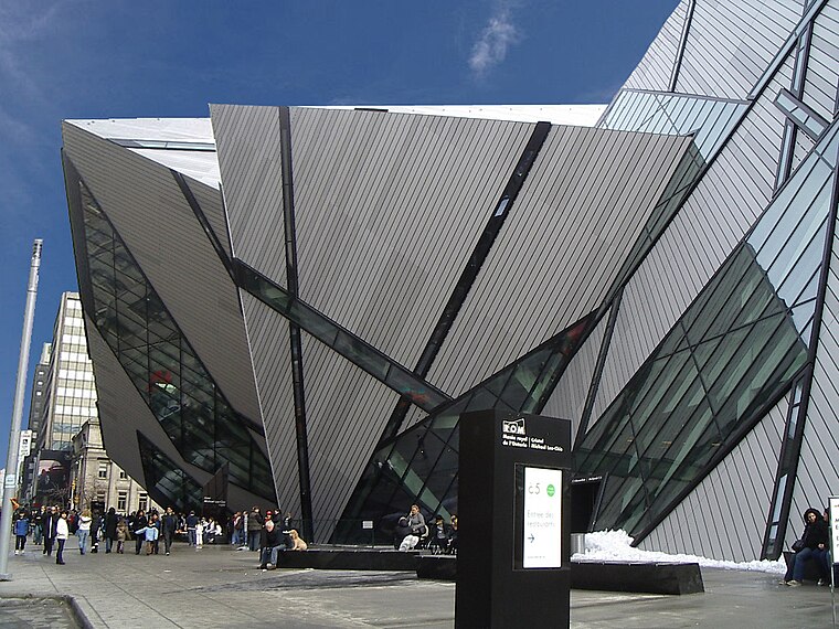
Photo: Staka, CC BY-SA 4.0.
The Royal Ontario Museum is a museum of art, world culture and natural history in Toronto, Ontario, Canada. It is one of the largest museums in North America and the largest in Canada. Royal Ontario Museum is situated 590 metres north of The Mackenzie-Papineu Battalion.
Places in the Area
Nearby places include Discovery District and Yorkville.
Discovery District
Neighborhood

Photo: Cmglee, CC BY-SA 3.0.
The Discovery District is one of the commercial districts in Downtown Toronto, Ontario, Canada. It has a high concentration of hospitals and research institutions, particularly those related to biotechnology.
Yorkville
Neighborhood

Photo: Haaron755, CC BY-SA 3.0.
Yorkville is a neighbourhood and former village in Toronto, Ontario, Canada. It is roughly bounded by Bloor Street to the south, Davenport Road to the north, Yonge Street to the east and Avenue Road to the west, and it is part of The Annex neighbourhood.
Church and Wellesley
Neighborhood

Photo: Wikimedia, CC BY-SA 3.0.
Church and Wellesley is an LGBT-oriented enclave in Toronto, Ontario, Canada. It is roughly bounded by Gerrard Street to the south, Yonge Street to the west, Charles Street to the north, and Jarvis Street to the east, with the core commercial strip located along Church Street from Wellesley south to Alexander.
The Mackenzie-Papineu Battalion
- Type: Memorial
- Category: historic site
- Location: Old Toronto, Toronto, Greater Toronto Area, Ontario, Canada, North America
- View on OpenStreetMap
Latitude
43.66256° or 43° 39′ 45″ northLongitude
-79.39274° or 79° 23′ 34″ westOpen location code
87M2MJ74+2WOpenStreetMap ID
node 11184405611OpenStreetMap feature
historic=memorial
This page is based on OpenStreetMap, Wikidata, and Wikimedia Commons.
We’d love your help improving our open data sources. Thank you for contributing.
Satellite Map
Discover The Mackenzie-Papineu Battalion from above in high-definition satellite imagery.
Notable Places Nearby
Highlights include William Lyon Mackenzie Monument and Gerstein Field.
Nearby Places
Explore places such as Jesus Christ and Centre of Criminology, School of Public Policy & Governance.
Toronto: Must-Visit Destinations
Delve into Yorkville and the Annex, Midtown, East End, and Downtown East.
Curious Memorials to Discover
Uncover intriguing memorials from every corner of the globe.
About Mapcarta. Data © OpenStreetMap contributors and available under the Open Database License". Text is available under the CC BY-SA 4.0 license, except for photos, directions, and the map. Photo: S23678, CC BY-SA 3.0.