Famery Craft Beer Outlet
Famery Craft Beer Outlet is a liquor store in Manitoba, Prairies which is located on Donald Street. Famery Craft Beer Outlet is situated nearby to Bend Academy, as well as near McConnell School of Irish Dance.| Tap on a place to explore it |
- Opening hours:
Monday—Saturday: 9:00 AM—11:00 PM
Sunday: noon—11:00 PM - Type: Liquor store
- Address: 2 Donald Street
Places of Interest Nearby
Highlights include Canada Life Centre and Manitoba Legislative Building.
Canada Life Centre
Stadium
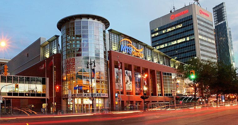 Canada Life Centre is an indoor arena in downtown Winnipeg, Manitoba, Canada. It is the home of the National Hockey League's Winnipeg Jets and their American Hockey League affiliate, the Manitoba Moose. Canada Life Centre is situated 1½ km north of Famery Craft Beer Outlet.
Manitoba Legislative Building
Public building
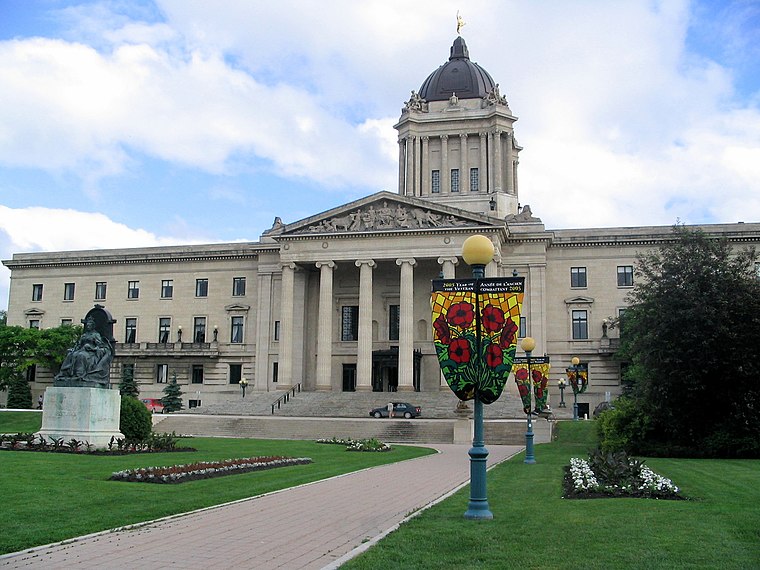
Photo: Canucks4ever83, Public domain.
The Manitoba Legislative Building, originally named the Manitoba Parliament Building, is the meeting place of the Legislative Assembly of Manitoba, located in central Winnipeg, as well as being the twelfth provincial heritage site of Manitoba. Manitoba Legislative Building is situated 1 km northwest of Famery Craft Beer Outlet.
Dalnavert
Museum

Photo: Jessloso, CC BY-SA 4.0.
Dalnavert, also known as Macdonald House, is a historic house museum in downtown Winnipeg, Manitoba, Canada. Dalnavert was constructed in 1895 as a private residence for Sir Hugh John Macdonald, a lawyer, politician, and former premier of Manitoba. Dalnavert is situated 1 km north of Famery Craft Beer Outlet.
Places in the Area
Nearby places include Confusion Corner and Osborne Village.
Confusion Corner
Locality

Photo: Wikimedia, CC BY-SA 2.0.
Osborne Junction, more commonly known as Confusion Corner, is a street intersection in Winnipeg, Manitoba. Located at the junction of City Route 62 and City Route 42 in the city's Fort Rouge neighbourhood, the intersection is a major traffic hub through which…
Osborne Village
Neighborhood
 Osborne Village is a neighbourhood of Winnipeg, Manitoba. The area is bordered by the Assiniboine River on the north and west, Harkness Station on the east, and the Osborne Underpass on the south.
Armstrong’s Point
Neighborhood

Photo: Qwekiop147, CC BY 3.0.
Armstrong's Point is a neighbourhood in Winnipeg, Manitoba. It is located in the West End of the city and in a large bend in the Assiniboine River. The land was developed in the late 19th and early 20th centuries as a residential district.
Famery Craft Beer Outlet
- Category: shop
- Location: Manitoba, Prairies, Canada, North America
- View on OpenStreetMap
Latitude
49.87784° or 49° 52′ 40″ northLongitude
-97.13915° or 97° 8′ 21″ westOperator
Famery Estate BreweryOpen location code
86X4VVH6+48OpenStreetMap ID
node 11196266040OpenStreetMap feature
shop=alcohol
This page is based on OpenStreetMap, Wikidata, and Wikimedia Commons.
We’d love your help improving our open data sources. Thank you for contributing.
Satellite Map
Discover Famery Craft Beer Outlet from above in high-definition satellite imagery.
Notable Places Nearby
Highlights include Bend Academy and McConnell School of Irish Dance.
Nearby Places
Explore places such as Soho Blinds and The UPS Store.
Manitoba: Must-Visit Destinations
Delve into Winnipeg, Churchill, Brandon, and Thompson.
Curious Liquor Stores to Discover
Uncover intriguing liquor stores from every corner of the globe.
About Mapcarta. Data © OpenStreetMap contributors and available under the Open Database License". Text is available under the CC BY-SA 4.0 license, except for photos, directions, and the map. Photo: Wikimedia, CC0.