Zam Zam Halal Supermarkt
Zam Zam Halal Supermarkt is a convenience store in Frankfurt, South Hesse, Hesse. Zam Zam Halal Supermarkt is situated nearby to the square Emilie-und-Oskar-Schindler-Platz, as well as near Angel Hotel.| Tap on a place to explore it |
Places of Interest Nearby
Highlights include Frankfurt Hauptbahnhof and Frankfurt Stock Exchange.
Frankfurt Hauptbahnhof
Railway station
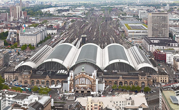
Photo: Der Wolf im Wald, CC BY-SA 3.0 de.
Frankfurt Hauptbahnhof is the busiest train station in the German state of Hesse and the second most busy train station in Germany behind Hamburg Hauptbahnhof. Frankfurt Hauptbahnhof is situated 240 metres southwest of Zam Zam Halal Supermarkt.
Frankfurt Stock Exchange
Marketplace
 The Frankfurt Stock Exchange is the world's 3rd oldest and 12th largest stock exchange by market capitalization. It has operations from 8:00 am to 10:00 pm. Frankfurt Stock Exchange is situated 1¼ km northeast of Zam Zam Halal Supermarkt.
Städel
Museum

Photo: Simsalabimbam, CC BY-SA 3.0.
The Städel, officially the Städelsches Kunstinstitut und Städtische Galerie, is an art museum in Frankfurt, with one of the most important collections in Germany. Städel is situated 780 metres southeast of Zam Zam Halal Supermarkt.
Places in the Area
Nearby places include Bahnhofsviertel and Westend.
Bahnhofsviertel
Suburb

Photo: Luisfff2812, CC BY 4.0.
The Bahnhofsviertel is a quarter of Frankfurt am Main, Germany. It is part of the Ortsbezirk Innenstadt I. The Bahnhofsviertel was developed between 1891 and 1915.
Westend
Suburb

Photo: Wikimedia, CC BY-SA 3.0.
Westend-Nord and Westend-Süd are two city districts of Frankfurt am Main, Germany. The division into a northern and a southern part is mostly for administrative purposes as the Westend is generally considered an entity.
Sachsenhausen
Suburb
Sachsenhausen-Nord and Sachsenhausen-Süd are two quarters of Frankfurt am Main, Germany. The division into a northern and a southern part is mostly for administrative purposes as Sachsenhausen is generally considered a single entity.
Zam Zam Halal Supermarkt
- Type: Convenience store
- Wheelchair access: yes
- Categories: shop and food
- Location: Frankfurt, South Hesse, Hesse, Germany, Central Europe, Europe
- View on OpenStreetMap
Latitude
50.10777° or 50° 6′ 28″ northLongitude
8.66539° or 8° 39′ 55″ eastOpen location code
9F2C4M58+45OpenStreetMap ID
node 11262959517OpenStreetMap feature
shop=convenienceOpenStreetMap attribute
wheelchair=yes
This page is based on OpenStreetMap, Wikidata, and Wikimedia Commons.
We’d love your help improving our open data sources. Thank you for contributing.
Satellite Map
Discover Zam Zam Halal Supermarkt from above in high-definition satellite imagery.
Notable Places Nearby
Highlights include Emilie-und-Oskar-Schindler-Platz and Angel Hotel.
Nearby Places
Explore places such as Frittenwerk and Frankfurt Hostel.
South Hesse: Must-Visit Destinations
Delve into Darmstadt, Bensheim, Lorsch, and Heppenheim.
Curious Convenience Stores to Discover
Uncover intriguing convenience stores from every corner of the globe.
About Mapcarta. Data © OpenStreetMap contributors and available under the Open Database License". Text is available under the CC BY-SA 4.0 license, except for photos, directions, and the map. Photo: Mylius, GFDL.