Social Security Administration
Social Security Administration is a government office in Queens, New York. Social Security Administration is situated nearby to the dog park Wag N Bone, as well as near the health club Fortified Holistic LLC.| Tap on a place to explore it |
Places of Interest Nearby
Highlights include Museum of the Moving Image and 36th Avenue station.
Museum of the Moving Image
Museum

Photo: NickCPrior, CC BY-SA 3.0.
The Museum of the Moving Image is a media museum located in a former building of the historic Astoria Studios, in the Astoria neighborhood of Queens in New York City. Museum of the Moving Image is situated 2,000 feet east of Social Security Administration.
36th Avenue station
Metro station

Photo: Mtattrain, CC BY-SA 4.0.
The 36th Avenue station is a local station on the BMT Astoria Line of the New York City Subway. It is located at the intersection of 36th Avenue and 31st Street in Astoria, Queens. 36th Avenue station is situated 750 feet north of Social Security Administration.
39th Avenue station
Metro station
 The 39th Avenue station is a local station on the BMT Astoria Line of the New York City Subway. It is located at 39th Avenue and 31st Street in Long Island City, Queens. The station is served by the N train at all times, as well as by the W train on weekdays. 39th Avenue station is situated 930 feet southwest of Social Security Administration.
Places in the Area
Nearby places include Harold Interlocking and Sunnyside Gardens.
Harold Interlocking
Locality
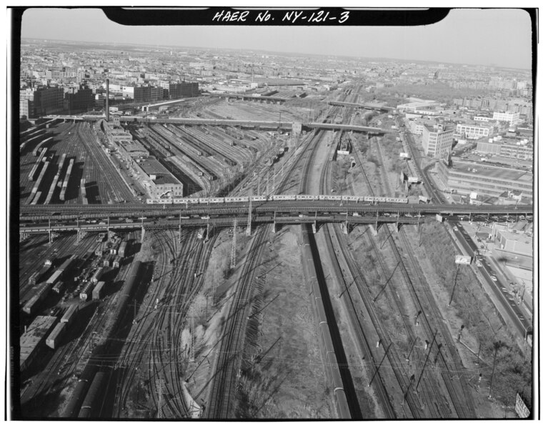
Photo: Jack Boucher, Public domain.
Harold Interlocking is a large railroad junction in New York City. The busiest rail junction in the United States, it serves trains on Amtrak's Northeast Corridor and the Long Island Rail Road's Main Line and Port Washington Branch, which diverge at the junction.
Sunnyside Gardens
Neighborhood
Sunnyside Gardens is a community within Sunnyside, a neighborhood in the New York City borough of Queens. The area was the first development in the United States patterned after the ideas of the garden city movement initiated in England in the first decades of the twentieth century by Ebenezer Howard and Raymond Unwin, specifically Hampstead Garden Suburb and Letchworth Garden City.
Metro New York

Photo: S23678, CC BY-SA 3.0.
Metro New York or Greater New York, also called the Tri-State Area, is the massive metropolitan area around New York City in the states of New York, Connecticut, New Jersey and Pennsylvania. It is the biggest and wealthiest metro area in the United States.
Social Security Administration
- Type: Government office
- Categories: office and government building
- Location: Queens, New York, Mid-Atlantic, United States, North America
- View on OpenStreetMap
Latitude
40.75465° or 40° 45′ 17″ northLongitude
-73.93081° or 73° 55′ 51″ westOperator
Social Security AdministrationOpen location code
87G8Q339+VMOpenStreetMap ID
node 11278151796OpenStreetMap feature
office=government
This page is based on OpenStreetMap, Wikidata, and Wikimedia Commons.
We’d love your help improving our open data sources. Thank you for contributing.
Satellite Map
Discover Social Security Administration from above in high-definition satellite imagery.
Places with the Same Name
Discover other places named “Social Security Administration”.
Notable Places Nearby
Highlights include Wag N Bone and Fortified Holistic LLC.
Nearby Places
Explore places such as Queens Lutheran School and Astoria Seafood.
Queens: Must-Visit Destinations
Delve into John F. Kennedy International Airport, LaGuardia Airport, Flushing-Northeast, and Long Island City and Astoria.
Curious Government Offices to Discover
Uncover intriguing government offices from every corner of the globe.
About Mapcarta. Data © OpenStreetMap contributors and available under the Open Database License". Text is available under the CC BY-SA 4.0 license, except for photos, directions, and the map. Photo: Wikimedia, CC BY-SA 3.0.