Flying_bike
Flying_bike is a bike rental in Casablanca, North Atlantic Coast. Flying_bike is situated nearby to the park Promenade Maritime de la Mosquée Hassan II, as well as near the college Institut Spécialisé de Technologie Appliquée El Hank المعهد المتخصص للتكنولوجيا التطبيقية العنق.| Tap on a place to explore it |
Places of Interest Nearby
Highlights include El Hank Lighthouse and Beth El Synagogue.
El Hank Lighthouse
Lighthouse

Photo: Sambasoccer27, CC BY-SA 4.0.
The El Hank lighthouse is a lighthouse located on the tip of El Hank, west of the port of Casablanca. It is managed by the Port and Maritime Authority within the Ministry of Equipment, Transport, Logistics and Water. El Hank Lighthouse is situated 1 km northwest of Flying_bike.
Beth El Synagogue
Synagogue
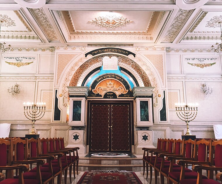
Photo: Sambasoccer27, CC BY-SA 4.0.
The Temple Beth-El is an Orthodox Jewish congregation and synagogue, located at 67 Rue Jaber ben Hayane, in the Sidi Belyout district of Casablanca, Morocco. Beth El Synagogue is situated 2 km southeast of Flying_bike.
Lycée Lyautey
School

Photo: Wikimedia, CC BY-SA 3.0.
Lycée Lyautey is a French institution of secondary education located in Casablanca, Morocco. It is composed of a collège and a lycée, and belongs to the Académie de Bordeaux, an educational administrative district in France. Lycée Lyautey is situated 1¼ km southeast of Flying_bike.
Places in the Area
Nearby places include El Hank and Bourgogne.

Flying_bike
- Type: Bike rental
- Category: transportation
- Location: Casablanca, Casablanca-Settat, North Atlantic Coast, Morocco, North Africa, Africa
- View on OpenStreetMap
Latitude
33.60484° or 33° 36′ 17″ northLongitude
-7.64447° or 7° 38′ 40″ westOpen location code
8C5JJ934+W6OpenStreetMap ID
node 11417474490OpenStreetMap feature
amenity=bicycle_rental
This page is based on OpenStreetMap, Wikidata, and Wikimedia Commons.
We’d love your help improving our open data sources. Thank you for contributing.
Satellite Map
Discover Flying_bike from above in high-definition satellite imagery.
Notable Places Nearby
Highlights include Promenade Maritime de la Mosquée Hassan II and Institut Spécialisé de Technologie Appliquée El Hank المعهد المتخصص للتكنولوجيا التطبيقية العنق.
Nearby Places
Explore places such as Promenade maritime and Garmin maroc.
North Atlantic Coast: Must-Visit Destinations
Delve into Rabat, El Jadida, Larache, and Asilah.
Curious Bike Rentals to Discover
Uncover intriguing bike rentals from every corner of the globe.
About Mapcarta. Data © OpenStreetMap contributors and available under the Open Database License". Text is available under the CC BY-SA 4.0 license, except for photos, directions, and the map. Photo: elchicogris, CC BY-SA 2.0.