Kamelhof Fleckschnupphof
Kamelhof Fleckschnupphof is a recreation area in Löwenberger Land, Oberhavel, Brandenburg. Kamelhof Fleckschnupphof is situated nearby to Village church Nassenheide, as well as near the fire station Freiwillige Feuerwehr Nassenheide.| Tap on a place to explore it |
Places of Interest Nearby
Highlights include Village church Nassenheide and Nassenheide station.
Village church Nassenheide
Church

Photo: DorisAntony, CC BY-SA 4.0.
Village church Nassenheide is situated 100 metres east of Kamelhof Fleckschnupphof.
Nassenheide station
Railway station
Nassenheide station is a railway station in the Nassenheide district in the municipality of Löwenberger Land, located in the Oberhavel district in Brandenburg, Germany. Nassenheide station is situated 1½ km east of Kamelhof Fleckschnupphof.
Places in the Area
Nearby places include Sachsenhausen and Friedrichsthal, Oranienburg.
Sachsenhausen
Suburb
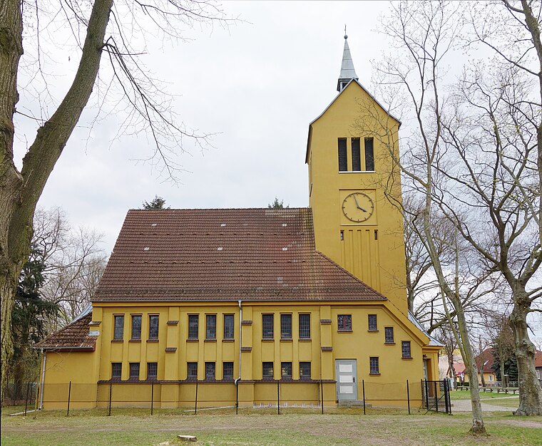
Photo: Hans G. Oberlack, CC BY-SA 4.0.
Sachsenhausen is a district on the Havel River in the north of the town Oranienburg, 35 kilometres north of Berlin in Germany. As of December 2005, it had a population of 2,735. The district's name means 'Houses of the Saxons'. Sachsenhausen is situated 4½ km southeast of Kamelhof Fleckschnupphof.
Friedrichsthal, Oranienburg
Suburb

Photo: Saxo, Public domain.
Friedrichsthal, Oranienburg is a suburb, which is situated 4½ km southeast of Kamelhof Fleckschnupphof.
Teschendorf
Village

Photo: Wikitour, CC BY-SA 3.0.
Teschendorf is a village, which is situated 5 km northwest of Kamelhof Fleckschnupphof.
Kamelhof Fleckschnupphof
- Type: Equestrianism
- Categories: recreation area and sports location
- Location: Löwenberger Land, Oberhavel, Brandenburg, Germany, Central Europe, Europe
- View on OpenStreetMap
Latitude
52.81485° or 52° 48′ 54″ northLongitude
13.21415° or 13° 12′ 51″ eastOpen location code
9F4MR677+WMOpenStreetMap ID
node 11465304848OpenStreetMap feature
leisure=horse_riding
This page is based on OpenStreetMap, Wikidata, and Wikimedia Commons.
We’d love your help improving our open data sources. Thank you for contributing.
Satellite Map
Discover Kamelhof Fleckschnupphof from above in high-definition satellite imagery.
Notable Places Nearby
Highlights include Kamelhof and Freiwillige Feuerwehr Nassenheide.
Nearby Places
Explore places such as Dorfgemeinschaftshaus and Nassenheide, Kirche.
Brandenburg: Must-Visit Destinations
Delve into Potsdam, Cottbus, Frankfurt an der Oder, and Brandenburg an der Havel.
Curious Places to Discover
Uncover intriguing places from every corner of the globe.
About Mapcarta. Data © OpenStreetMap contributors and available under the Open Database License". Text is available under the CC BY-SA 4.0 license, except for photos, directions, and the map. Photo: Leviathan1983, CC BY-SA 3.0.