Der Tüllinger Wald
Der Tüllinger Wald is in Lörrach, Freiburg Region, Baden-Württemberg. Der Tüllinger Wald is situated nearby to the fountain Hornbrunnen, as well as near Weiherle-Brünnle.| Tap on a place to explore it |
Places of Interest Nearby
Highlights include Vitra Design Museum and Tüllinger Berg.
Vitra Design Museum
Museum
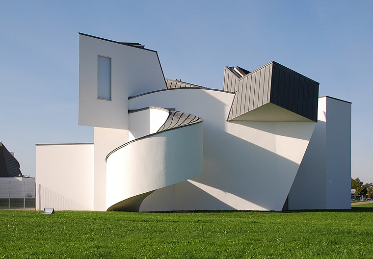
Photo: Taxiarchos228, CC BY-SA 3.0.
The Vitra Design Museum is a privately owned museum for design in Weil am Rhein, Germany. The architect of this building was Frank O. Gehry. His architecture was based on the art movement of the early 20th century, deconstructivism. Vitra Design Museum is situated 2 km southwest of Der Tüllinger Wald.
Tüllinger Berg
Peak
The Tüllinger Berg short form Tüllinger, also known as Tüllinger Hügel in Switzerland, is a partly forested mountain located at an elevation of 460.2 m above sea level.
Burghof Lörrach
Theater building

Photo: Wikimedia, CC BY-SA 3.0.
Burghof Lörrach is a theater building, which is situated 1½ km east of Der Tüllinger Wald.
Places in the Area
Nearby places include Ötlingen and Haltingen.
Ötlingen
Village

Photo: Wikimedia, CC BY-SA 3.0.
Ötlingen is a Stadtteil and Ortschaft of Weil am Rhein, Baden-Württemberg, Germany. It is located on the northwestern foothills of the Tüllinger Berg. Once an independent community, this area was incorporated into Weil am Rhein in 1971.

Rötteln
Hamlet
Rötteln is a hamlet beneath the ruins of Rötteln Castle, which was once home to the Lords of Rötteln. Today it is part of the quarter of Haagen, in the city of Lörrach, Baden-Württemberg. Rötteln is situated 2½ km northeast of Der Tüllinger Wald.
Der Tüllinger Wald
- Type: Sign
- Categories: information and tourism
- Location: Lörrach, Lörrach, Freiburg Region, Black Forest, Baden-Württemberg, Germany, Central Europe, Europe
- View on OpenStreetMap
Latitude
47.61307° or 47° 36′ 47″ northLongitude
7.63801° or 7° 38′ 17″ eastOpen location code
8FV9JJ7Q+66OpenStreetMap ID
node 11649927091OpenStreetMap feature
tourism=information
This page is based on OpenStreetMap, Wikidata, and Wikimedia Commons.
We’d love your help improving our open data sources. Thank you for contributing.
Satellite Map
Discover Der Tüllinger Wald from above in high-definition satellite imagery.
Notable Places Nearby
Highlights include Hornbrunnen and Weiherle-Brünnle.
Nearby Places
Explore places such as Käferholz and Daur-Hütte.
Black Forest: Must-Visit Destinations
Delve into Freiburg, Baden-Baden, Pforzheim, and Offenburg.
Curious Places to Discover
Uncover intriguing places from every corner of the globe.
About Mapcarta. Data © OpenStreetMap contributors and available under the Open Database License". Text is available under the CC BY-SA 4.0 license, except for photos, directions, and the map. Photo: Taxiarchos228, CC BY-SA 2.0 de.