Pūtiki Pā
Pūtiki Pā is a historic site in Manawatū–Whanganui, New Zealand. Pūtiki Pā is situated nearby to the school Te Kura Kaupapa Māori o Te Atihaunui-A-Paparangi, as well as near St Paul’s Memorial Church, Putiki.| Tap on a place to explore it |
- Type: Historic site
- Description: pā located on the Whanganui River in Whanganui
- Also known as: “Putiki Pā / Te Pūtiki-wharanui-a-Tamatea-pōkai-whenua”
Places of Interest Nearby
Highlights include Royal Whanganui Opera House and Cooks Gardens.
Royal Whanganui Opera House
Theater building

Photo: Wikimedia, CC BY-SA 2.0.
The Royal Whanganui Opera House is a theatre located in Whanganui, New Zealand. Built in 1899, it is New Zealand's last Victorian theatre. Located on St Hill Street in central Whanganui, the theatre seats 830 and is a venue for many local, national and international events. Royal Whanganui Opera House is situated 1¼ km north of Pūtiki Pā.
Cooks Gardens
Park

Photo: Rudolph89, CC BY-SA 3.0.
Cooks Gardens is a multi-purpose stadium in Wanganui, New Zealand. It is currently used mostly for rugby union matches, athletics and cycling. The main stadium, known as Westpac Stadium, is able to hold 20,700 people with 3,500 covered seats. Cooks Gardens is situated 1¼ km north of Pūtiki Pā.
Ward Observatory
Observatory
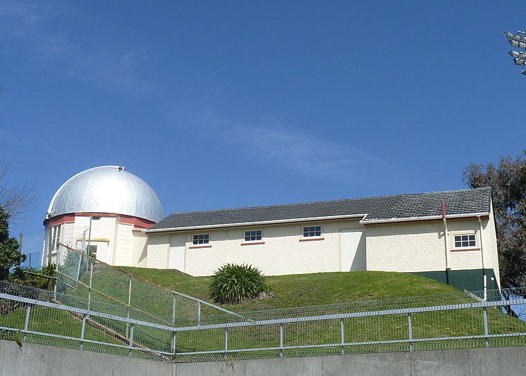
Photo: Podzemnik, CC BY-SA 4.0.
The Ward Observatory is an astronomical observatory in Whanganui, New Zealand. Built in 1901 and administered by the Wanganui Astronomical Society, it is named after Joseph Ward, the society's first president and longtime director of the observatory. Ward Observatory is situated 1½ km north of Pūtiki Pā.
Places in the Area
Nearby places include Putiki and Whanganui.
Putiki
Suburb
Putiki is a settlement in the Whanganui District and Manawatū-Whanganui region of New Zealand's North Island, located across the Whanganui River from Whanganui city.
Whanganui

Photo: Ripdog2121, CC BY-SA 3.0.
Whanganui or Wanganui is a city on the west coast of the North Island of New Zealand. It lies at the mouth of the Whanganui River, which flows from Mount Tongariro via the stunning Whanganui National Park. The district has a population of about 48,000 in 2022.
College Estate
Quarter
College Estate is a suburb of Whanganui, in the Whanganui District and Manawatū-Whanganui region of New Zealand's North Island.
Pūtiki Pā
- Categories: pā, tourist attraction, and tourism
- Location: Manawatū–Whanganui, New Zealand, Oceania
- View on OpenStreetMap
Latitude
-39.94622° or 39° 56′ 46″ southLongitude
175.04959° or 175° 2′ 59″ eastOpen location code
4VGQ323X+GROpenStreetMap ID
node 11681307856OpenStreetMap feature
historic=yesWikidata ID
Q103932643
This page is based on OpenStreetMap, Wikidata, and Wikimedia Commons.
We’d love your help improving our open data sources. Thank you for contributing.
Satellite Map
Discover Pūtiki Pā from above in high-definition satellite imagery.
In Other Languages
From Maori to Turkish—“Pūtiki Pā” goes by many names.
- Maori: “Te Pūtiki-wharanui-a-Tamatea-pōkai-whenua”
- Turkish: “Pūtiki Pā”
Places with the Same Name
Discover other places named “Pūtiki Pā”.
Notable Places Nearby
Highlights include Te Kura Kaupapa Māori o Te Atihaunui-A-Paparangi and St. Paul’s Memorial Church Putiki.
Nearby Places
Explore places such as Taupo Quay Substation and Mitre 10 MEGA.
New Zealand: Must-Visit Destinations
Delve into Auckland, Wellington, Canterbury, and Christchurch.
Curious Historic Sites to Discover
Uncover intriguing historic sites from every corner of the globe.
About Mapcarta. Data © OpenStreetMap contributors and available under the Open Database License". Text is available under the CC BY-SA 4.0 license, except for photos, directions, and the map. Photo: Inkey, Public domain.