Établissement financier
Établissement financier is a money transmitter in Centre Region, Cameroon. Établissement financier is situated nearby to Library, as well as near the public building Ministère de la Recherche Scientifique et del’Innovation.| Tap on a place to explore it |
Places of Interest Nearby
Highlights include National Museum of Cameroon and Blackitude Museum.
National Museum of Cameroon
Museum

Photo: Z. NGNOGUE, CC BY-SA 3.0.
National Museum of Cameroon is situated 1¼ km east of Établissement financier.
Blackitude Museum
Museum
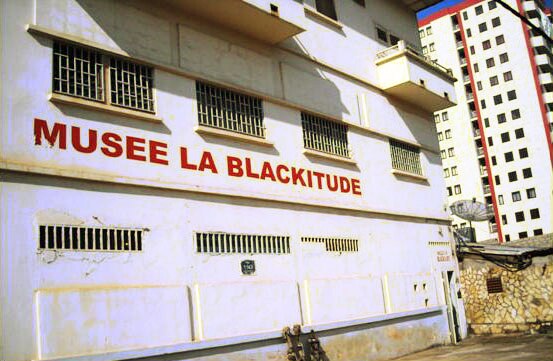
Photo: Awinda, CC BY-SA 3.0.
The Blackitude Museum is a private ethnographic institution. It is located in the city center of Yaoundé behind the Presidential Tribune on the Boulevard du 20 Mai, in the Central Region of Cameroon. Blackitude Museum is situated 1½ km east of Établissement financier.
Yaoundé Multipurpose Sports Complex
Sports venue

Photo: Bdx, CC BY-SA 4.0.
The Yaoundé Multipurpose Sports Complex is an indoor sporting arena located in Yaoundé, Cameroon. The capacity of the Palais des sports de Warda is 5,263 people. Yaoundé Multipurpose Sports Complex is situated 1½ km northeast of Établissement financier.
Places in the Area
Nearby places include Yaoundé.
Yaoundé

Photo: Bdx, CC BY-SA 4.0.
Yaoundé is the capital of Cameroon, and the country's second most populous city. It is smaller than the economic centre, but still a bustling city. Called the city on seven hills, Yaoundé is home to people from all over Cameroon.
Établissement financier
- Type: Money transmitter
- Location: Centre Region, Cameroon, Central Africa, Africa
- View on OpenStreetMap
Latitude
3.86123° or 3° 51′ 40″ northLongitude
11.50539° or 11° 30′ 19″ eastOpen location code
6FMHVG64+F5OpenStreetMap ID
node 11752575586OpenStreetMap feature
amenity=mobile_money_agent
This page is based on OpenStreetMap, Wikidata, and Wikimedia Commons.
We’d love your help improving our open data sources. Thank you for contributing.
Satellite Map
Discover Établissement financier from above in high-definition satellite imagery.
Notable Places Nearby
Highlights include Library and Ministère de la Recherche Scientifique et del’Innovation.
Nearby Places
Explore places such as Institut de Recherches Médicales et d’Etudes des Plantes Médicinales and Cetic de ngoa ekele.
Cameroon: Must-Visit Destinations
Delve into Yaoundé, Douala, Adamaoua, and Mount Cameroon.
Curious Money Transmitters to Discover
Uncover intriguing money transmitters from every corner of the globe.
About Mapcarta. Data © OpenStreetMap contributors and available under the Open Database License". Text is available under the CC BY-SA 4.0 license, except for photos, directions, and the map. Photo: Jjtkk, CC BY-SA 3.0.