Coal Miner
Coal Miner is a public artwork by Polish American artist John J. Szaton which is located in two US State capitals; the original, commissioned in 1963 in Springfield, Illinois, as well as a copy on the west lawn of the Indiana State House in Indianapolis The statues commemorate coal miners who had lost their lives in those states' mining industry.| Tap on a place to explore it |
- Type: Work of art
- Artwork type: statue
- Description: artwork by John J. Szaton
- Also known as: “The Coal Miner”
Places of Interest Nearby
Highlights include Indiana State House and Indiana Government Center North.
Indiana State House
Public building

Photo: Dschwen, CC BY-SA 3.0.
The Indiana Statehouse is the state capitol building of the U.S. state of Indiana. It houses the Indiana General Assembly, the office of the Governor of Indiana, the Indiana Supreme Court, and other state officials.
Indiana Government Center North
Public building

Photo: Serge Melki, CC BY 2.0.
Indiana Government Center North is a high rise in Indianapolis, Indiana. It was completed in 1960 and has 14 floors. It is primarily used for office spaces for the government of Indiana. Indiana Government Center North is situated 570 feet west of Coal Miner.
Gainbridge Fieldhouse
Stadium
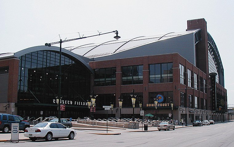
Photo: Durin, CC BY-SA 3.0.
Gainbridge Fieldhouse is an indoor arena in downtown Indianapolis, Indiana, United States. It opened in November 1999 to replace Market Square Arena. The arena is the home of the Indiana Pacers of the National Basketball Association and the Indiana Fever of the Women's National Basketball Association. Gainbridge Fieldhouse is situated 2,800 feet southeast of Coal Miner.
Places in the Area
Nearby places include Indianapolis and Mass Ave Cultural Arts District.
Indianapolis

Photo: Prabhakar Koduri, CC BY 2.0.
Indianapolis is the capital of Indiana and also the state’s largest city. Efforts to beautify and modernize the city have brought Indianapolis into the 21st century as a world-class destination for everything from business meetings and trade conventions to backpackers making their way across the States.
Mass Ave Cultural Arts District
Neighborhood

Photo: Jim.henderson, CC BY-SA 3.0.
The Mass Ave Cultural Arts District, colloquially known as Mass Ave, is one of seven designated cultural districts in Indianapolis, Indiana, United States.
Chatham–Arch, Indianapolis
Locality

Photo: Nyttend, Public domain.
Chatham–Arch is a neighborhood located immediately east of Downtown Indianapolis, Indiana, United States. This neighborhood is one of the oldest in Indianapolis, dating back to the mid 19th century.
Coal Miner
- Categories: sculpture and tourism
- Location: Center Township, Marion, Indiana, Midwest, United States, North America
- View on OpenStreetMap
Latitude
39.76898° or 39° 46′ 8″ northLongitude
-86.16316° or 86° 9′ 47″ westInception
1966Open location code
86FMQR9P+HPOpenStreetMap ID
node 11799181818OpenStreetMap feature
tourism=artworkOpenStreetMap attribute
artwork_type=statueWikidata ID
Q5137750
This page is based on OpenStreetMap, Wikidata, Wikimedia Commons, and Wikipedia.
We’d love your help improving our open data sources. Thank you for contributing.
Satellite Map
Discover Coal Miner from above in high-definition satellite imagery.
In Other Languages
From French to Hindi—“Coal Miner” goes by many names.
- French: “Coal Miner”
- Hindi: “coal miner”
Notable Places Nearby
Highlights include Indiana Law Enforcement and Firefighters Memorial and LITEBoxIN-- ISL.
Nearby Places
Explore places such as Lux Aeterna and Time Flow.
Indiana: Must-Visit Destinations
Delve into Indianapolis, Fort Wayne, Gary, and Evansville.
Curious Work Of Arts to Discover
Uncover intriguing work of arts from every corner of the globe.
About Mapcarta. Data © OpenStreetMap contributors and available under the Open Database License". Text is available under the CC BY-SA 4.0 license, except for photos, directions, and the map. Description text is based on the Wikipedia page “Coal Miner”. Photo: Wikimedia, CC0.