Cyprus Avenue
Cyprus Avenue is a nightclub in Cork, Munster which is located on Oliver Plunkett Street. Cyprus Avenue is situated nearby to the shopping center Winthrop Arcade, as well as near the health club FLYEfit.| Tap on a place to explore it |
- Opening hours:
Monday: 7:00 PM—11:30 PM
Tuesday—Friday: midnight—2:00 AM and 7:00 PM—midnight
Saturday: midnight—2:30 AM and 7:00 PM—midnight
Sunday: midnight—2:30 AM and 7:00 PM—11:30 PM - Type: Nightclub
- Address: 113 Oliver Plunkett Street, Cork, T12 PY8A
- Wheelchair access: yes
Places of Interest Nearby
Highlights include English Market and Cork Opera House.
English Market
Marketplace

Photo: Rainer Ebert, CC BY-SA 2.0.
The English Market is a municipal food market in the center of Cork city, Ireland. It stretches from Princes Street to the Grand Parade, and combines Princes Street Market and Grand Parade Market. English Market is situated 310 metres west of Cyprus Avenue.
Cork Opera House
Theater building

Photo: Charlesolivercork, CC BY-SA 4.0.
Cork Opera House is a theatre and opera house in Cork in Ireland. The first venue opened in 1855 on Emmet Place to the rear of the Crawford Art Gallery. Cork Opera House is situated 310 metres northwest of Cyprus Avenue.
Huguenot Cemetery

Photo: Slongy, CC BY-SA 4.0.
Huguenot Cemetery was created between 1710 and 1733 as a cemetery for the Huguenot inhabitants in the city of Cork. It is believed to be one of the last two surviving Huguenot graveyards in western Europe. Huguenot Cemetery is situated 270 metres west of Cyprus Avenue.
Places in the Area
Nearby places include Shandon and Turner’s Cross.
Shandon
Suburb

Photo: psyberartist, CC BY 2.0.
Shandon is a district on the north-side of Cork city. Shandon lies north of the River Lee and North Gate Bridge, the northernmost point of the medieval city.
Turner’s Cross
Suburb
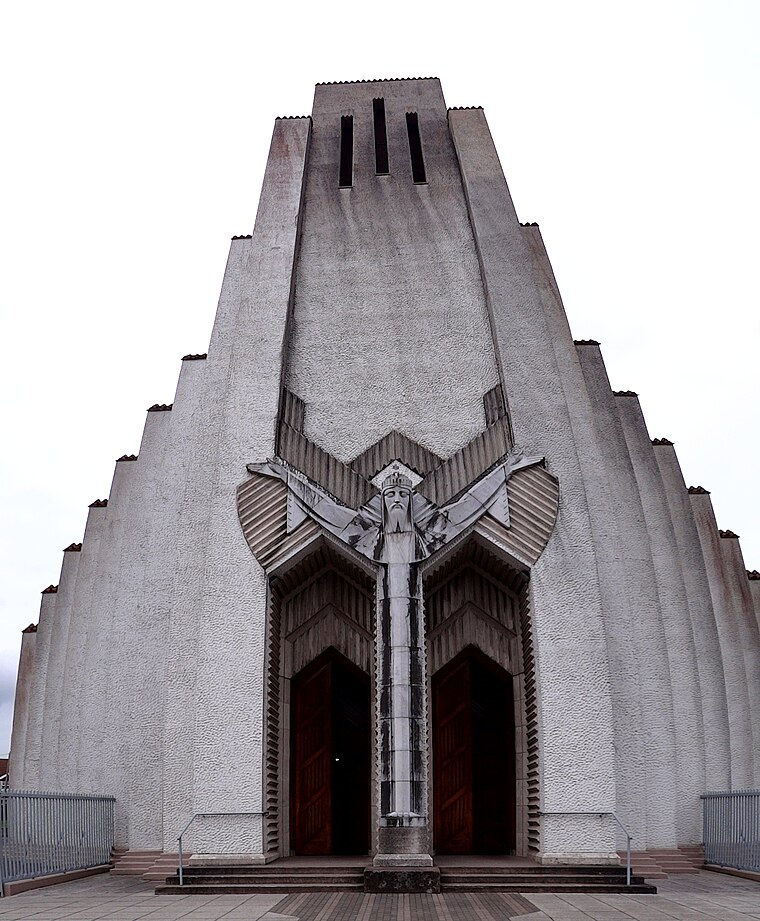
Photo: Uspn, CC BY-SA 3.0.
Turners Cross is a ward on the south side of Cork City in Ireland, and home to the Roman Catholic parish of the same name. Largely residential, one of the key features of the area is the iconic church created by architect Barry Byrne and sculptor John Storrs, the Church of Christ the King.
Blackpool
Suburb

Photo: Sebastian “sebrem” B…, CC BY-SA 3.0.
Blackpool is a suburb of Cork city in County Cork, Ireland. It is situated in the north of the city, on the N20 road to Mallow. Blackpool is part of the Cork North Central Dáil constituency.
Cyprus Avenue
- Location: Cork, Munster, Ireland, Britain and Ireland, Europe
- View on OpenStreetMap
Latitude
51.89834° or 51° 53′ 54″ northLongitude
-8.46981° or 8° 28′ 11″ westOpen location code
9C3HVGXJ+83OpenStreetMap ID
node 11925173866OpenStreetMap feature
amenity=nightclubOpenStreetMap attribute
wheelchair=yes
This page is based on OpenStreetMap, Wikidata, and Wikimedia Commons.
We’d love your help improving our open data sources. Thank you for contributing.
Satellite Map
Discover Cyprus Avenue from above in high-definition satellite imagery.
Places with the Same Name
Discover other places named “Cyprus Avenue”.
Notable Places Nearby
Highlights include FLYEfit and Winthrop Arcade.
Nearby Places
Explore places such as 115 Cafe & Wine Bar and The Old Oak.
Ireland: Must-Visit Destinations
Delve into Dublin, Limerick, Galway, and Waterford.
Curious Nightclubs to Discover
Uncover intriguing nightclubs from every corner of the globe.
About Mapcarta. Data © OpenStreetMap contributors and available under the Open Database License". Text is available under the CC BY-SA 4.0 license, except for photos, directions, and the map. Photo: psyberartist, CC BY 2.0.