Cherry St / Lake Shore Blvd E
Cherry St / Lake Shore Blvd E is a bike rental in Old Toronto, Toronto, Ontario. Cherry St / Lake Shore Blvd E is situated nearby to the work of art Still Dancing, as well as near the theater building Young Centre for the Performing Arts.| Tap on a place to explore it |
Places of Interest Nearby
Highlights include Ookwemin Minising and Young Centre for the Performing Arts.
Ookwemin Minising
Island

Photo: booledozer, CC0.
Ookwemin Minising is a 39.6 hectares artificial island in Toronto's Port Lands. It is bordered by the Keating Channel to the north, the Don River to the east and south, and Toronto Harbour to the west.
Young Centre for the Performing Arts
Theater building

Photo: Themightyquill, CC BY-SA 4.0.
The Young Centre for the Performing Arts is a theatre in the Distillery District in downtown Toronto, Canada. It is a brand-new theatre built into 19th-century-era Victorian industrial buildings. Young Centre for the Performing Arts is situated 320 metres north of Cherry St / Lake Shore Blvd E.
Scotiabank Arena
Stadium
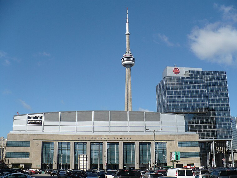
Photo: Secondarywaltz, Public domain.
Scotiabank Arena, formerly known as Air Canada Centre, is a multi-purposed arena located on Bay Street in downtown Toronto, Ontario, Canada. It is the home of the Toronto Raptors of the National Basketball Association and the Toronto Maple Leafs of the National Hockey League. Scotiabank Arena is situated 2 km west of Cherry St / Lake Shore Blvd E.
Places in the Area
Nearby places include Distillery District and Canary District.
Distillery District
Neighborhood

Photo: Mathew Ingram, CC BY 2.0.
The Distillery District is a commercial and residential district in Toronto, Ontario, Canada, east of downtown, which contains numerous cafés, restaurants, and shops housed within heritage buildings of the former Gooderham and Worts Distillery.
Canary District
Neighborhood
The Canary District is a planned neighbourhood in Toronto's West Don Lands mixed-use development. The area was formerly industrial land, cut off from the city by an elevated roadway and two rail corridors, sitting in a floodplain.
Port Lands
Neighborhood

Photo: SimonP, CC BY-SA 3.0.
The Port Lands of Toronto, Ontario, Canada are an industrial and recreational neighbourhood located about 5 kilometres south-east of downtown, located on the former Don River delta and most of Ashbridge's Bay.
Cherry St / Lake Shore Blvd E
- Type: Bike rental
- Category: transportation
- Location: Old Toronto, Toronto, Greater Toronto Area, Ontario, Canada, North America
- View on OpenStreetMap
Latitude
43.64813° or 43° 38′ 53″ northLongitude
-79.35647° or 79° 21′ 23″ westBrand
Bike Share TorontoOperator
Toronto Parking AuthorityOpen location code
87M2JJXV+6COpenStreetMap ID
node 11926777799OpenStreetMap feature
amenity=bicycle_rental
This page is based on OpenStreetMap, Wikidata, and Wikimedia Commons.
We’d love your help improving our open data sources. Thank you for contributing.
Satellite Map
Discover Cherry St / Lake Shore Blvd E from above in high-definition satellite imagery.
Notable Places Nearby
Highlights include Still Dancing and Geroge Brown Theatre School.
Nearby Places
Explore places such as Quayside and Cherry Street Stormwater Management Facility.
Toronto: Must-Visit Destinations
Delve into Yorkville and the Annex, Midtown, East End, and Downtown East.
Curious Bike Rentals to Discover
Uncover intriguing bike rentals from every corner of the globe.
About Mapcarta. Data © OpenStreetMap contributors and available under the Open Database License". Text is available under the CC BY-SA 4.0 license, except for photos, directions, and the map. Photo: S23678, CC BY-SA 3.0.