Höhenweg 2
Höhenweg 2 is a recreation area in Urdorf, Dietikon District, Canton of Zurich. Höhenweg 2 is situated nearby to the recreation area Höhenweg 1, as well as near Reservoir und Pumpwerk Weid.| Tap on a place to explore it |
Places of Interest Nearby
Highlights include Urdorf railway station and Bruder Klaus.
Urdorf railway station
Railway station
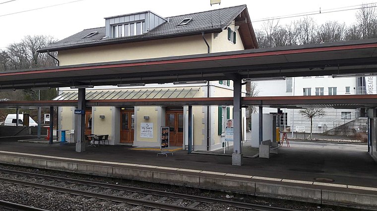 Urdorf is a railway station in the Swiss canton of Zurich. The station is situated close to the boundary of the municipalities of Schlieren and Urdorf and, whilst it is actually in the former, it takes its name from the latter. Urdorf railway station is situated 600 metres north of Höhenweg 2.
Bruder Klaus
Church

Photo: Charly Bernasconi, CC BY-SA 3.0.
Bruder Klaus is a church, which is situated 650 metres northwest of Höhenweg 2.
Urdorf Weihermatt railway station
Railway stop
 Urdorf Weihermatt is a railway station in the municipality of Urdorf, in the Swiss canton of Zurich. The station is located on the Zurich to Zug via Affoltern am Albis railway line, within fare zone 154 of the Zürcher Verkehrsverbund. Urdorf Weihermatt railway station is situated 690 metres southwest of Höhenweg 2.
Places in the Area
Nearby places include Schlieren and Uitikon.
Schlieren
Town

Photo: Roland zh, CC BY-SA 3.0.
Schlieren is a municipality in the district of Dietikon in the canton of Zürich in Switzerland.
Uitikon
Village

Photo: Roland zh, CC BY-SA 3.0.
Uitikon is a village and municipality in the district of Dietikon in the canton of Zürich in Switzerland. Besides the village of Uitikon itself, the municipality includes the villages of Waldegg and Ringlikon.
Waldegg
Village

Photo: Vincent.bloch, CC BY-SA 4.0.
Waldegg is a village, which is situated 3 km southeast of Höhenweg 2.
Höhenweg 2
- Type: Recreation area
- Categories: tourist attraction and tourism
- Location: Urdorf, Dietikon District, Canton of Zurich, Switzerland, Central Europe, Europe
- View on OpenStreetMap
Latitude
47.38557° or 47° 23′ 8″ northLongitude
8.43636° or 8° 26′ 11″ eastOpen location code
8FVC9CPP+6GOpenStreetMap ID
node 11961273558OpenStreetMap feature
leisure=firepit
This page is based on OpenStreetMap, Wikidata, and Wikimedia Commons.
We’d love your help improving our open data sources. Thank you for contributing.
Satellite Map
Discover Höhenweg 2 from above in high-definition satellite imagery.
Notable Places Nearby
Highlights include Höhenweg 1 and Reservoir und Pumpwerk Weid.
Nearby Places
Explore places such as Weid and Schürhof.
Switzerland: Must-Visit Destinations
Delve into Zurich, Berne, Geneva, and Basel.
Curious Recreation Areas to Discover
Uncover intriguing recreation areas from every corner of the globe.
About Mapcarta. Data © OpenStreetMap contributors and available under the Open Database License". Text is available under the CC BY-SA 4.0 license, except for photos, directions, and the map. Photo: Wikimedia, CC0.