Levante Sud
Levante Sud is a pitch in Zonza, Arrondissement of Sartène, Corsica. Levante Sud is situated nearby to the pitch Noca, as well as near Levante Est.| Tap on a place to explore it |
Places of Interest Nearby
Highlights include Col de Bavella and Punta di l’Acellu.

Places in the Area
Nearby places include Aiguilles de Bavella and Quenza.
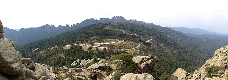
Aiguilles de Bavella
Locality

Photo: Wikimedia, CC BY-SA 3.0.
The Aiguilles de Bavella are rocky spikes of red granite that dominate the hill of the same name on the island of Corsica in France. At 1218 m, the hill connects the Alta Rocca to the east coast of Corsica.
Quenza
Village

Photo: Pierre Bona, CC BY-SA 4.0.
Quenza is a commune in the department of Corse-du-Sud, island and collectivity of Corsica, France. Quenza is situated 8 km southwest of Levante Sud.
Levante Sud
- Type: Pitch
- Categories: climbing site, recreation area, and sports location
- Location: Zonza, Arrondissement of Sartène, South Corsica, Corsica, France, Europe
- View on OpenStreetMap
Latitude
41.79849° or 41° 47′ 55″ northLongitude
9.22194° or 9° 13′ 19″ eastOpen location code
8FHFQ6XC+9QOpenStreetMap ID
node 11972230885OpenStreetMap feature
leisure=pitchOpenStreetMap feature
sport=climbing
This page is based on OpenStreetMap, Wikidata, and Wikimedia Commons.
We’d love your help improving our open data sources. Thank you for contributing.
Satellite Map
Discover Levante Sud from above in high-definition satellite imagery.
Notable Places Nearby
Highlights include Noca and Levante Est.
Nearby Places
Explore places such as Croix de Leccia and Notre-Dame des Neiges.
Corsica: Must-Visit Destinations
Delve into Ajaccio, Bastia, Bonifacio, and Calvi.
Curious Pitches to Discover
Uncover intriguing pitches from every corner of the globe.
About Mapcarta. Data © OpenStreetMap contributors and available under the Open Database License". Text is available under the CC BY-SA 4.0 license, except for photos, directions, and the map. Photo: Pierre Bona, CC BY-SA 3.0.