Anton & Anni (Z 58)
Anton & Anni (Z 58) is a fast food restaurant in Frankfurt, South Hesse, Hesse. Anton & Anni (Z 58) is situated nearby to the playground Lufthansa, as well as near the airport terminal Terminal 1 Flugsteig A-Plus.| Tap on a place to explore it |
Places of Interest Nearby
Highlights include Frankfurt Airport and Frankfurt Airport long-distance station.
Frankfurt Airport

Photo: Epizentrum, CC BY-SA 3.0.
Frankfurt Airport is the largest airport in Germany and a global aviation hub on the outskirts of Frankfurt am Main in the state of Hesse.
Frankfurt Airport long-distance station
Railway station
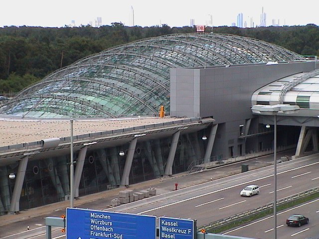
Photo: Wikimedia, CC BY-SA 3.0.
Frankfurt am Main Airport long-distance station is a railway station at Frankfurt Airport in Frankfurt, Germany. It is served by long-distance trains, mostly ICE services running on the Cologne–Frankfurt high-speed rail line. Frankfurt Airport long-distance station is situated 800 metres northeast of Anton & Anni (Z 58).
Frankfurt am Main Airport Regional trains
Railway station

Photo: Jivee Blau, CC BY-SA 3.0.
Frankfurt Airport regional station is an underground railway station at Frankfurt Airport in Frankfurt, Germany. It provides local S-Bahn and Regionalbahn services to the city and the Frankfurt/Rhine-Main Metropolitan Region. Frankfurt am Main Airport Regional trains is situated 790 metres northeast of Anton & Anni (Z 58).
Places in the Area
Nearby places include Kelsterbacher Terrasse and Schwedenschanze Kelsterbach.
Kelsterbacher Terrasse
Locality

Photo: Frank Behnsen, CC BY-SA 3.0.
Kelsterbacher Terrasse is a locality.
Schwedenschanze Kelsterbach
Locality

Photo: Frank Winkelmann, CC BY 3.0.
Schwedenschanze Kelsterbach is a locality, which is situated 2½ km northwest of Anton & Anni (Z 58).
Kelsterbach

Photo: Andrew-k, CC BY-SA 3.0.
Kelsterbach, also called Kelsterbach am Main for its position on the banks of the Main River into which the Kelsterbach flows, is in Hesse.
Anton & Anni (Z 58)
- Type: Fast food restaurant
- Categories: food and restaurant
- Location: Frankfurt, South Hesse, Hesse, Germany, Central Europe, Europe
- View on OpenStreetMap
Latitude
50.0478° or 50° 2′ 52″ northLongitude
8.5621° or 8° 33′ 44″ eastOpen location code
9F2C2HX6+4ROpenStreetMap ID
node 12073179669OpenStreetMap feature
amenity=fast_food
This page is based on OpenStreetMap, Wikidata, and Wikimedia Commons.
We’d love your help improving our open data sources. Thank you for contributing.
Satellite Map
Discover Anton & Anni (Z 58) from above in high-definition satellite imagery.
Notable Places Nearby
Highlights include Lufthansa and Terminal 1 Flugsteig A-Plus.
Nearby Places
Explore places such as McDonalds (Z58) and napcabs.
South Hesse: Must-Visit Destinations
Delve into Darmstadt, Bensheim, Lorsch, and Heppenheim.
Curious Fast Food Restaurants to Discover
Uncover intriguing fast food restaurants from every corner of the globe.
About Mapcarta. Data © OpenStreetMap contributors and available under the Open Database License". Text is available under the CC BY-SA 4.0 license, except for photos, directions, and the map. Photo: Mylius, GFDL.