McDonald’s PlayPlace
McDonald’s PlayPlace is a playground in Maricopa County, Arizona. McDonald’s PlayPlace is situated nearby to the church Hope Evangelistic Community Center, as well as near Greater Hope Deliverence Temple.| Tap on a place to explore it |
Places of Interest Nearby
Highlights include Chase Field and Mortgage Matchup Center.
Chase Field
Stadium
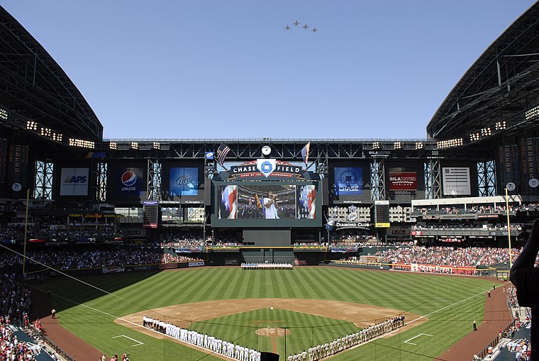
Photo: Wikimedia, Public domain.
Chase Field, formerly Bank One Ballpark, is a retractable-roof stadium in downtown Phoenix, Arizona, United States. It is the ballpark of Major League Baseball's Arizona Diamondbacks. Chase Field is situated 1 mile north of McDonald’s PlayPlace.
Mortgage Matchup Center
Stadium
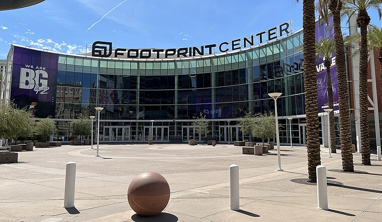
Photo: Troutfarm27, CC BY-SA 4.0.
Mortgage Matchup Center is a multi-purpose arena in Phoenix, Arizona. It opened under the name America West Arena on June 6, 1992, at a cost of $89 million. Mortgage Matchup Center is situated 1¼ miles north of McDonald’s PlayPlace.
Carver High School
Museum

Photo: Marine 69-71, CC BY-SA 3.0.
Carver High School was a public high school in Phoenix, Arizona, established to serve African-American students during a time of school segregation. The school was constructed in 1926. Carver High School is situated 4,000 feet north of McDonald’s PlayPlace.
Places in the Area
Nearby places include Phoenix and Central City.
Phoenix

Photo: DPPed, CC BY-SA 3.0.
Phoenix is the capital of the state of Arizona, the most populous city in the American Southwest. Warm and sunny winter weather have ensured a thriving tourism industry, and the city has become the region's primary political, cultural, economic, and transportation center.
Central City
Suburb
Photo: Jimmybeverage, Public domain.
Central City Village is the urban village of Phoenix, Arizona, that includes the downtown area of the city. As of 2010, it had a population of 58,161 residents.
South Phoenix
Neighborhood
South Phoenix is a region of Phoenix, Arizona. By one definition it encompasses an area south of the Salt River, north of Baseline Road, east of 51 Avenue, and west of 48 Street. South Phoenix is situated 1½ miles south of McDonald’s PlayPlace.
McDonald’s PlayPlace
- Type: Playground
- Category: recreation area
- Location: Maricopa County, Arizona, Southwest, United States, North America
- View on OpenStreetMap
Latitude
33.42978° or 33° 25′ 47″ northLongitude
-112.06558° or 112° 3′ 56″ westBrand
McDonald’sOpen location code
8559CWHM+WQOpenStreetMap ID
node 12076241462OpenStreetMap feature
leisure=playground
This page is based on OpenStreetMap, Wikidata, and Wikimedia Commons.
We’d love your help improving our open data sources. Thank you for contributing.
Satellite Map
Discover McDonald’s PlayPlace from above in high-definition satellite imagery.
Places with the Same Name
Discover other places named “McDonald’s PlayPlace”.
Notable Places Nearby
Highlights include Hope Evangelistic Community Center and Greater Hope Deliverence Temple.
Nearby Places
Explore places such as McDonald’s and Liberty Auto Group.
Arizona: Must-Visit Destinations
Delve into Phoenix, Tucson, Mesa, and Flagstaff.
Curious Playgrounds to Discover
Uncover intriguing playgrounds from every corner of the globe.
About Mapcarta. Data © OpenStreetMap contributors and available under the Open Database License". Text is available under the CC BY-SA 4.0 license, except for photos, directions, and the map. Photo: Tobi 87, CC BY-SA 3.0.