José da Cunha
José da Cunha is a bus stop in Real, Dume e Semelhe, Braga. José da Cunha is situated nearby to the village Real, as well as near the church Capela de São Lourenço da Ordem.| Tap on a place to explore it |
Places of Interest Nearby
Highlights include Estádio Municipal de Braga and Chapel of São Frutuoso.
Estádio Municipal de Braga
Stadium

Photo: Manuel Anastácio, CC BY-SA 3.0.
The Estádio Municipal de Braga is an all-seater football stadium located in Braga, Portugal, and the current home of Sporting Clube de Braga. It has a capacity of 30,286 spectators, making it the seventh largest football stadium in Portugal. Estádio Municipal de Braga is situated 580 metres northeast of José da Cunha.
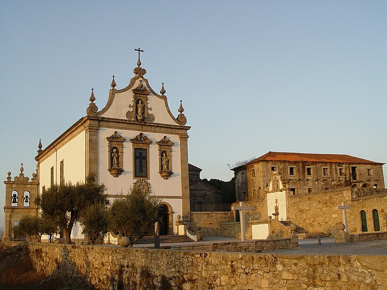
Chapel of São Frutuoso
Church

Photo: Joseolgon, CC BY-SA 4.0.
The Chapel of São Frutuoso, also known as the Chapel of São Frutuoso of Montélios or the Chapel of São Salvador of Montélios, is a pre-Romanesque chapel in the civil parish of Real, municipality of Braga. Chapel of São Frutuoso is situated 290 metres west of José da Cunha.
Convento de São Francisco
Museum

Photo: Joseolgon, CC BY-SA 4.0.
Convento de São Francisco is a museum, which is situated 270 metres northwest of José da Cunha.
Places in the Area
Nearby places include Real and Dume.
Dume
Village

Photo: Joseolgon, CC BY-SA 3.0.
Dume is a former freguesia and former bishopric in the municipality of Braga, northern Portugal, which remains a Catholic titular see. In 2013, the parish merged into the new parish Real, Dume e Semelhe.
São Vicente
Suburb
Photo: Joseolgon, CC BY-SA 4.0.
São Vicente is a Portuguese freguesia, located in the municipality of Braga. The population in 2011 was 13,236, in an area of 2.55 km². In São Vicente is located the Faculty of Philosophy part of Catholic University of Portugal, the Escola Secundária Sá de Miranda and the Colégio D.
José da Cunha
- Type: Bus stop
- Category: transportation
- Location: Real, Dume e Semelhe, Braga, Braga District, Portugal, Iberia, Europe
- View on OpenStreetMap
Latitude
41.55943° or 41° 33′ 34″ northLongitude
-8.43556° or 8° 26′ 8″ westOpen location code
8CHHHH57+QQOpenStreetMap ID
node 12163670380OpenStreetMap feature
highway=bus_stopOpenStreetMap feature
public_transport=platform
This page is based on OpenStreetMap, Wikidata, and Wikimedia Commons.
We’d love your help improving our open data sources. Thank you for contributing.
Satellite Map
Discover José da Cunha from above in high-definition satellite imagery.
Notable Places Nearby
Highlights include Capela de São Lourenço da Ordem and Cemitério de Real.
Nearby Places
Explore places such as Manuel Guimarães and S. Jerónimo.
Portugal: Must-Visit Destinations
Delve into Lisbon, Caldas da Rainha, Porto, and Coimbra.
Curious Bus Stops to Discover
Uncover intriguing bus stops from every corner of the globe.
About Mapcarta. Data © OpenStreetMap contributors and available under the Open Database License". Text is available under the CC BY-SA 4.0 license, except for photos, directions, and the map. Photo: Jjtkk, CC BY 3.0.