East Busway - near Amtrak/Greyhound
East Busway - near Amtrak/Greyhound is a bus station in Pittsburgh, Allegheny County, Pennsylvania. East Busway - near Amtrak/Greyhound is situated nearby to the bus station Penn Station, as well as near the railway station Union Station.| Tap on a place to explore it |
Places of Interest Nearby
Highlights include Union Station and PPG Paints Arena.
Union Station
Railway station

Photo: Ram-Man, CC BY-SA 2.5.
Union Station, also known as Pennsylvania Station and commonly called Penn Station, is a historic train station in Downtown Pittsburgh, Pennsylvania. It was one of several passenger rail stations that served Pittsburgh during the 20th century; others included…
PPG Paints Arena
Stadium
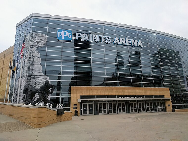
Photo: Jleedev, CC BY-SA 4.0.
PPG Paints Arena is a multi-purpose indoor arena in Pittsburgh, Pennsylvania, that serves as the home of the Pittsburgh Penguins of the National Hockey League. PPG Paints Arena is situated 1,700 feet southeast of East Busway - near Amtrak/Greyhound.
William S. Moorhead Federal Building
Government office

Photo: VitaleBaby, Public domain.
The William S. Moorhead Federal Building is a 340-foot -tall skyscraper that is located in downtown Pittsburgh, Pennsylvania, United States. Plans for the building were announced on November 9, 1958, and the structure was completed in 1964. William S. Moorhead Federal Building is situated 740 feet west of East Busway - near Amtrak/Greyhound.
Places in the Area
Nearby places include Uptown Pittsburgh and Downtown Pittsburgh.
Uptown Pittsburgh
Neighborhood
Photo: Ronjamin, CC BY-SA 2.5.
Uptown or The Bluff is a neighborhood in the city of Pittsburgh, Pennsylvania, to the southeast of the city's Central Business District. It is bordered in the north by the Hill District and located across the Monongahela River from South Side.
Downtown Pittsburgh

Photo: Chris connelly, CC BY 2.0.
Downtown Pittsburgh is the main business district and urban center of life in the city. Constrained by the Allegheny River on the north and the Monongahela River on the south, which join to form the Ohio River at what is known as the "Point", Downtown has been forced to grow upwards.
Hill District
Neighborhood
The Hill District is a grouping of historically African American neighborhoods in the City of Pittsburgh, Pennsylvania. Beginning in the years leading up to World War I, "the Hill" was the cultural center of black life in the city and a major center of jazz.
East Busway - near Amtrak/Greyhound
- Type: Bus station
- Categories: station and transportation
- Location: Pittsburgh, Allegheny County, Pittsburgh Region, Pennsylvania, Mid-Atlantic, United States, North America
- View on OpenStreetMap
Latitude
40.44387° or 40° 26′ 38″ northLongitude
-79.99206° or 79° 59′ 31″ westNetwork
Pittsburgh Regional TransitOpen location code
87G2C2V5+G5OpenStreetMap ID
node 12184874017OpenStreetMap feature
amenity=bus_stationOpenStreetMap feature
public_transport=station
This page is based on OpenStreetMap, Wikidata, and Wikimedia Commons.
We’d love your help improving our open data sources. Thank you for contributing.
Satellite Map
Discover East Busway - near Amtrak/Greyhound from above in high-definition satellite imagery.
Notable Places Nearby
Highlights include Penn Station and Pittsburgh Union Station.
Nearby Places
Explore places such as Penn Station and East Busway + Penn Station C.
Pittsburgh: Must-Visit Destinations
Delve into Oakland, Downtown Pittsburgh, South Side, and Strip District-Lawrenceville.
Curious Bus Stations to Discover
Uncover intriguing bus stations from every corner of the globe.
About Mapcarta. Data © OpenStreetMap contributors and available under the Open Database License". Text is available under the CC BY-SA 4.0 license, except for photos, directions, and the map. Photo: Robpinion, CC BY-SA 3.0.