Lernort Keibelstraße
Lernort Keibelstraße is a museum in Berlin, Berlin which is located on Bernhard-Weiß-Straße. Lernort Keibelstraße is situated nearby to the government office Senatsverwaltung für Bildung, Jugend und Familie, as well as near Jugendberufsagentur Berlin.| Tap on a place to explore it |
- Email: kontakt@keibelstrasse.de
- Type: Museum
- Also known as: “Untersuchungshaftanstalt Keibelstraße”
- Address: Bernhard-Weiß-Straße 6, Berlin, 10178
Places of Interest Nearby
Highlights include Alexanderplatz and Fernsehturm Berlin.
Alexanderplatz
Square
 Alexanderplatz is a large public square and transport hub in the central Mitte district of Berlin. The square is named after the Russian Tsar Alexander I, which also denotes the larger neighbourhood stretching from Mollstraße in the north-east to Spandauer Straße and the Rotes Rathaus in the south-west. Alexanderplatz is situated 350 metres southwest of Lernort Keibelstraße.
Fernsehturm Berlin
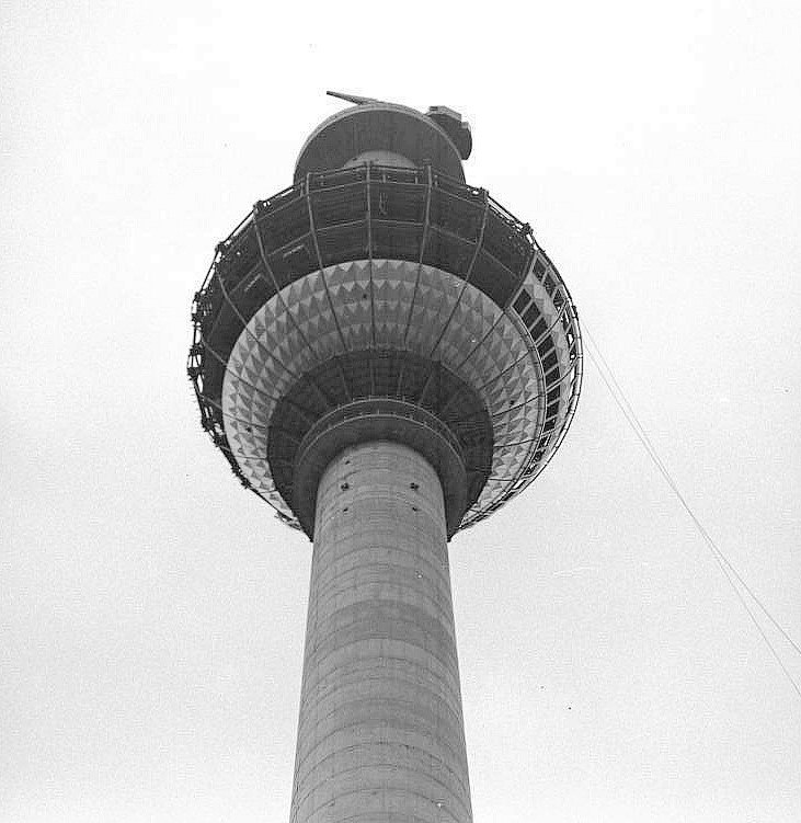
Photo: Wikimedia, CC BY-SA 3.0 de.
The Fernsehturm in central Berlin was constructed between 1965 and 1969 by the government of the German Democratic Republic as both a functional broadcasting facility and a symbol of Communist power. Fernsehturm Berlin is situated 620 metres southwest of Lernort Keibelstraße.
Berlin Alexanderplatz station
Railway station

Photo: IngolfBLN, CC BY-SA 2.0.
Berlin Alexanderplatz is a German railway station in the Mitte district of Berlin's city centre. It is one of the busiest transport hubs in the Berlin area, servicing surface-level trams and buses as well as the U-Bahn, S-Bahn, and regional rail. Berlin Alexanderplatz station is situated 470 metres southwest of Lernort Keibelstraße.
Places in the Area
Nearby places include Scheunenviertel and Alt-Berlin.
Scheunenviertel
Neighborhood
Scheunenviertel is a neighborhood of Mitte in the centre of Berlin. It is situated to the north of the medieval Altberlin area, east of the Rosenthaler Straße and Hackescher Markt.
Alt-Berlin
Locality

Photo: Sludge G, CC BY-SA 2.0.
Alt-Berlin, also spelled Altberlin, is a neighborhood, situated in the Berliner locality of Mitte, part of the homonymous borough. In the 13th century it was the sister town of the old Cölln, located on the northern Spree Island in the Margraviate of Brandenburg.
Mitte
 Mitte, literally meaning "the middle" and being a contraction of Stadtmitte, contains the historical heart of Berlin and represents in many ways the real centre of the city.
Lernort Keibelstraße
- Categories: tourism and tourist attraction
- Location: Berlin, Berlin, Stadt, Berlin, Germany, Central Europe, Europe
- View on OpenStreetMap
Latitude
52.52437° or 52° 31′ 28″ northLongitude
13.41654° or 13° 24′ 60″ eastInception
February 2019Operator
Agentur für Bildung, Geschichte und Politik e.V.Open location code
9F4MGCF8+PJOpenStreetMap ID
node 12357897312OpenStreetMap feature
tourism=museum
This page is based on OpenStreetMap, Wikidata, and Wikimedia Commons.
We’d love your help improving our open data sources. Thank you for contributing.
Satellite Map
Discover Lernort Keibelstraße from above in high-definition satellite imagery.
Notable Places Nearby
Highlights include Senatsverwaltung für Bildung, Jugend und Familie and Jugendberufsagentur Berlin.
Nearby Places
Explore places such as Wandel and Greet Berlin Alexanderplatz.
Berlin: Must-Visit Destinations
Delve into Mitte, East Central, City West, and East Berlin.
Curious Museums to Discover
Uncover intriguing museums from every corner of the globe.
About Mapcarta. Data © OpenStreetMap contributors and available under the Open Database License". Text is available under the CC BY-SA 4.0 license, except for photos, directions, and the map. Photo: Berthold Werner, CC BY-SA 3.0.