Water Table
Water Table is a work of art in Rochester, Rochester and Suburbs, New York. Water Table is situated nearby to Rundel Memorial Library, as well as near Central Library of Rochester & Monroe County.| Tap on a place to explore it |
Places of Interest Nearby
Highlights include Blue Cross Arena and Rundel Memorial Library.
Blue Cross Arena
Stadium
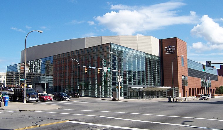
Photo: LtPowers, CC BY-SA 3.0.
Blue Cross Arena, also known as the War Memorial, is a multi-purpose indoor arena located in Rochester, New York. For hockey and lacrosse, its seating capacity is 10,662. Blue Cross Arena is situated 610 feet west of Water Table.
Rundel Memorial Library
Library

Photo: LtPowers, CC BY-SA 3.0.
The Rundel Memorial Building is a historic library building located at Rochester in Monroe County, New York. It is the original downtown site of the Rochester Public Library, and along with the Bausch & Lomb Library Building directly across the street, serves as the Central Library of Rochester and Monroe County.
Broad Street Bridge

Photo: AFBorchert, CC BY-SA 4.0.
Erie Canal: Second Genesee Aqueduct, also known as the Broad Street Aqueduct or Broad Street Bridge, is a historic stone aqueduct located at Rochester in Monroe County, New York. Broad Street Bridge is situated 350 feet west of Water Table.
Places in the Area
Nearby places include South Wedge Historic District and East Avenue Historic District.
South Wedge Historic District
Neighborhood
Photo: KLOTZ, CC BY-SA 4.0.
South Wedge is a historic district and neighborhood in southeast Rochester, New York, in a predominantly residential section of the city. The district includes a variety of buildings constructed between the 1840s and 1920s, mainly two-story detached family residences.
East Avenue Historic District
Neighborhood

Photo: Tim Pierce, CC BY-SA 3.0.
East Avenue Historic District is a national historic district located at Rochester in Monroe County, New York. The district consists of a series of large 19th and early 20th century homes, houses of worship, meeting houses, and museums. East Avenue Historic District is situated 1½ miles east of Water Table.
Brighton
Town

Photo: DanielPenfield, CC BY-SA 3.0.
Brighton is a town and census-designated place in Monroe County, New York, United States. The population was 37,137 at the 2020 census. Brighton is situated 3 miles southeast of Water Table.
Water Table
- Type: Work of art
- Artwork type: sculpture
- Category: tourism
- Location: Rochester, Rochester and Suburbs, Finger Lakes, New York, Mid-Atlantic, United States, North America
- View on OpenStreetMap
Latitude
43.15443° or 43° 9′ 16″ northLongitude
-77.6087° or 77° 36′ 31″ westOpen location code
87M4593R+QGOpenStreetMap ID
node 12363410244OpenStreetMap feature
tourism=artworkOpenStreetMap attribute
artwork_type=sculpture
This page is based on OpenStreetMap, Wikidata, and Wikimedia Commons.
We’d love your help improving our open data sources. Thank you for contributing.
Satellite Map
Discover Water Table from above in high-definition satellite imagery.
Notable Places Nearby
Highlights include Central Library of Rochester & Monroe County and South Avenue Garage Pocket Park.
Nearby Places
Explore places such as River Currents and Mill Wheel.
Rochester and Suburbs: Must-Visit Destinations
Delve into Fairport, East Rochester, Victor, and Spencerport.
Curious Work Of Arts to Discover
Uncover intriguing work of arts from every corner of the globe.
About Mapcarta. Data © OpenStreetMap contributors and available under the Open Database License". Text is available under the CC BY-SA 4.0 license, except for photos, directions, and the map. Photo: LtPowers, CC BY-SA 3.0.