Manflor
Manflor is a peak in Granada, Granada, Andalusia and has an elevation of 991 metres. Manflor is situated nearby to the locality Casas del Hornillo, as well as near Dehesa del Generalife.| Tap on a place to explore it |
Places of Interest
Highlights include Alhambra and Generalife.
Alhambra
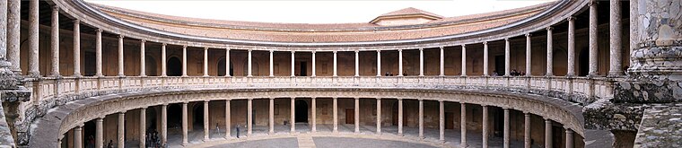
Photo: Bernd Untiedt, CC BY-SA 3.0.
The Alhambra is a palace and fortress complex located in Granada, Spain. It is one of the most famous monuments of Islamic architecture and one of the best-preserved palaces of the historic Islamic world.
Generalife

Photo: Jean-Pierre Dalbéra, CC BY 2.0.
The Generalife was a summer palace and country estate of the Nasrid rulers of the Emirate of Granada in Al-Andalus. It is located directly east of and uphill from the Alhambra palace complex in Granada, Spain.
Granada Cathedral
Church

Photo: Berthold Werner, CC BY-SA 3.0.
The Metropolitan Cathedral-Basilica of the Incarnation, is a Roman Catholic cathedral in the city of Granada, Spain. The cathedral is the seat of the Archdiocese of Granada.
Places in the Area
Nearby places include Jun and Albaicín.
Jun
Village

Photo: Lopezsuarez, CC0.
Jun is a Spanish locality and municipality situated in the north-centre part of la Vega de Granada, in the province of Granada. It limits with the municipalities of Pulianas, Granada, Alfacar and Víznar.
Albaicín
Quarter

Photo: Miguel303xm, CC BY-SA 2.5.
The Albaicín, also spelled Albayzín, is a neighbourhood of Granada, Spain. It is centered around a hill on the north side of the Darro River which passes through the city.
Maracena
Town

Photo: Emiliomaracena, CC BY-SA 4.0.
Maracena is a municipality located in the province of Granada, Spain. According to the 2005 census, the city has a population of 18819 inhabitants. It is located in the central part of the Vega de Granada, being one of the fifty-two entities that make up the metropolitan area of Granada.It borders the municipalities of Peligros, Pulianas, Granada, Atarfe and Albolote.
Manflor
Latitude
37.1895° or 37° 11′ 22″ northLongitude
-3.5706° or 3° 34′ 14″ westElevation
991 metres (3,251 feet)Open location code
8C9R5CQH+QPOpenStreetMap ID
node 1243320292OpenStreetMap feature
natural=peak
This page is based on OpenStreetMap, Wikidata, and Wikimedia Commons.
We’d love your help improving our open data sources. Thank you for contributing.
Satellite Map
Discover Manflor from above in high-definition satellite imagery.
Places with the Same Name
Discover other places named “Manflor”.
Localities in the Area
Explore places such as Casas del Hornillo and Dehesa del Generalife.
Notable Places Nearby
Highlights include Cerro del Tío Rojicas and Abadía del Sacromonte.
Granada: Must-Visit Destinations
Delve into Almuñécar, Alhama de Granada, Portugos, and La Alpujarra.
Curious Peaks to Discover
Uncover intriguing peaks from every corner of the globe.
About Mapcarta. Data © OpenStreetMap contributors and available under the Open Database License". Text is available under the CC BY-SA 4.0 license, except for photos, directions, and the map. Photo: Ogre, Public domain.