La pointe du Bouvet
La pointe du Bouvet is in Hyères, Arrondissement of Toulon, Provence-Alpes-Côte d’Azur. La pointe du Bouvet is situated nearby to the square Place Louis Coulomb, as well as near Underwater path with antique vases and wreck.| Tap on a place to explore it |
Places of Interest Nearby
Highlights include La Tour Fondue, Hyères and Église St Pierre (Hyères).
La Tour Fondue, Hyères
Fort
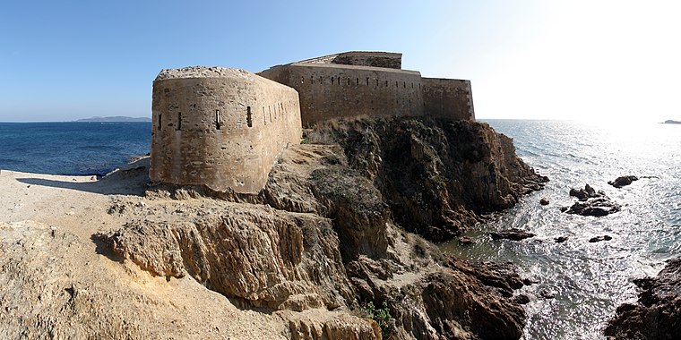
Photo: Kuebi, CC BY-SA 3.0.
La Tour Fondue, Hyères is a fort, which is situated 240 metres south of La pointe du Bouvet.
Église St Pierre (Hyères)
Church

Photo: Hyerestourisme, CC BY-SA 3.0.
Église St Pierre (Hyères) is a church, which is situated 2½ km northwest of La pointe du Bouvet.
Fort du Grand Langoustier
Castle

Photo: Technob105, CC BY-SA 3.0.
Fort du Grand Langoustier is a castle, which is situated 3½ km south of La pointe du Bouvet.
Places in the Area
Nearby places include La Capte.
La Capte
Suburb

Photo: Johnjohn83var, CC BY-SA 3.0.
La Capte is a suburb, which is situated 4 km north of La pointe du Bouvet.
La pointe du Bouvet
- Type: Sign
- Categories: information and tourism
- Location: Hyères, Arrondissement of Toulon, Var, Provence-Alpes-Côte d’Azur, France, Europe
- View on OpenStreetMap
Latitude
43.02841° or 43° 1′ 42″ northLongitude
6.15645° or 6° 9′ 23″ eastOpen location code
8FM825H4+9HOpenStreetMap ID
node 12463243552OpenStreetMap feature
tourism=information
This page is based on OpenStreetMap, Wikidata, and Wikimedia Commons.
We’d love your help improving our open data sources. Thank you for contributing.
Satellite Map
Discover La pointe du Bouvet from above in high-definition satellite imagery.
Notable Places Nearby
Highlights include Place Louis Coulomb and Underwater path with antique vases and wreck.
Nearby Places
Explore places such as Autour de la Mer and Au petit marché.
Var: Must-Visit Destinations
Delve into Toulon, Saint-Tropez, Fréjus, and Saint-Raphaël.
Curious Places to Discover
Uncover intriguing places from every corner of the globe.
About Mapcarta. Data © OpenStreetMap contributors and available under the Open Database License". Text is available under the CC BY-SA 4.0 license, except for photos, directions, and the map. Photo: ComputerHotline, CC BY 3.0.