Wunden der Erinnerung
Wunden der Erinnerung is a memorial in Munich, Upper Bavaria, Bavaria. Wunden der Erinnerung is situated nearby to the library Fachbibliothek Philologicum, as well as near the university building Ludwigstraße 25.| Tap on a place to explore it |
Places of Interest Nearby
Highlights include Ludwigskirche and University Library of the LMU Munich.
Ludwigskirche
Church

Photo: ErwinMeier, CC BY-SA 3.0.
The Catholic Parish and University Church of St. Louis, called Ludwigskirche, in Munich is a monumental church in Neo-Romanesque style with the second-largest altar fresco of the world.

Academy of Fine Arts, Munich
University
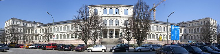
Photo: Wikimedia, CC BY-SA 3.0.
The Academy of Fine Arts, Munich is one of the oldest and most significant art academies in Germany. It is located in the Maxvorstadt district of Munich, in Bavaria, Germany. Academy of Fine Arts, Munich is situated 440 metres north of Wunden der Erinnerung.
Places in the Area
Nearby places include Lehel and Altstadt.

Altstadt

Photo: Ypsilon from Finland, CC0.
Altstadt meaning "old city" is the very heart of Munich. Three gates are all that remain of the medieval defensive walls, but within is a well-preserved district with many of Munich's iconic sights: twin-towered Frauenkirche, New City Hall with clockwork figures dancing to the chimes of its Glockenspiel, and Hofbräuhaus that temple to drinking and gorging.
Maxvorstadt

Photo: Tbp386, CC BY-SA 3.0.
Maxvorstadt is the arts and university district of Munich, just north of Altstadt the historic city centre.
Wunden der Erinnerung
- Type: Memorial
- Category: historic site
- Location: Munich, Upper Bavaria, Bavaria, Germany, Central Europe, Europe
- View on OpenStreetMap
Latitude
48.14916° or 48° 8′ 57″ northLongitude
11.58024° or 11° 34′ 49″ eastOpen location code
8FWH4HXJ+M3OpenStreetMap ID
node 12485076401OpenStreetMap feature
historic=memorial
This page is based on OpenStreetMap, Wikidata, and Wikimedia Commons.
We’d love your help improving our open data sources. Thank you for contributing.
Satellite Map
Discover Wunden der Erinnerung from above in high-definition satellite imagery.
Notable Places Nearby
Highlights include Fachbibliothek Philologicum and Ludwigstraße 25.
Nearby Places
Explore places such as Universität and Flowers (only warm season).
Munich: Must-Visit Destinations
Delve into North Munich, Altstadt, Haidhausen, and Ludwigsvorstadt-Isarvorstadt.
Curious Memorials to Discover
Uncover intriguing memorials from every corner of the globe.
About Mapcarta. Data © OpenStreetMap contributors and available under the Open Database License". Text is available under the CC BY-SA 4.0 license, except for photos, directions, and the map. Photo: Heav84, CC BY-SA 3.0.