‘Meine-Fähre-1’ -Autofähre-
‘Meine-Fähre-1’ -Autofähre- is a station in Norden, Aurich, Lower Saxony which is located on Poststrasse. ‘Meine-Fähre-1’ -Autofähre- is situated nearby to the tourism office Karten Fähre Norderney, as well as near the shipyard Störtebeker.| Tap on a place to explore it |
Places of Interest Nearby
Highlights include Norddeich station and Norddeich Mole station.
Norddeich station
Railway station
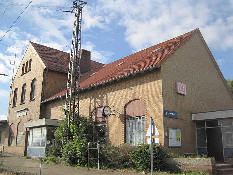
Photo: Stefan Flöper, CC BY-SA 4.0.
Norddeich is a railway station located in Norddeich, Lower Saxony, Germany. The station lies on the Emsland Railway and the train services are operated by Deutsche Bahn. Norddeich station is situated 630 metres south of ‘Meine-Fähre-1’ -Autofähre-.
Norddeich Mole station
Railway stop
 Norddeich Mole is a railway station located in Norddeich, Lower Saxony, Germany. The station is located on the Emsland Railway. The train services are operated by Deutsche Bahn. Norddeich Mole station is situated 330 metres southwest of ‘Meine-Fähre-1’ -Autofähre-.
Norden-Norddeich Airfield
Aerodrome

Photo: Carsten Steger, CC BY-SA 4.0.
Norden-Norddeich Airfield is an airfield near the northwestern Norden borough of Norddeich in Lower Saxony, Germany. The airport serves regular flights to airports on the islands of Norderney and until March 2025 Juist.
Places in the Area
Nearby places include Norden Norddeich and Bargebur.
Norden Norddeich

Photo: Mey2008, CC BY-SA 3.0.
Norden-Norddeich is a nice old North-Sea seaside town in the Eastern Frisia region of Lower Saxony in Germany. It is visited by many people, who spend their vacation there.
Bargebur
Suburb

Photo: Frisia Orientalis, CC BY-SA 3.0.
Bargebur is an urban quarter in the east of the borough of Norden, northwestern Germany, and has a population of around 500, who inhabit an area of just 0.65 km². Bargebur is situated 6 km southeast of ‘Meine-Fähre-1’ -Autofähre-.
Norderney

Photo: Carsten Steger, CC BY-SA 4.0.
Norderney is one of the East Frisian Islands, in the Northwest part of Lower Saxony in Germany. Norderney is a lively island with a beautiful sandy beach, spa treatments, and many restaurants and bars.
‘Meine-Fähre-1’ -Autofähre-
- Type: Station
- Address: Poststrasse 5, Norderney, 26548
- Categories: passenger ship terminal and transportation
- Location: Norden, Aurich, Lower Saxony, Germany, Central Europe, Europe
- View on OpenStreetMap
Latitude
53.6269° or 53° 37′ 37″ northLongitude
7.161° or 7° 9′ 40″ eastOperator
Meine Fähre GmbHOpen location code
9F59J5G6+Q9OpenStreetMap ID
node 12488084806OpenStreetMap feature
amenity=ferry_terminalOpenStreetMap feature
public_transport=station
This page is based on OpenStreetMap, Wikidata, and Wikimedia Commons.
We’d love your help improving our open data sources. Thank you for contributing.
Satellite Map
Discover ‘Meine-Fähre-1’ -Autofähre- from above in high-definition satellite imagery.
Places with the Same Name
Discover other places named “‘Meine-Fähre-1’ -Autofähre-”.
Notable Places Nearby
Highlights include Karten Fähre Norderney and Störtebeker.
Nearby Places
Explore places such as Ørsted Wind Power Germany GmbH and Ørsted Wind Power Germany GmbH.
Lower Saxony: Must-Visit Destinations
Delve into Hanover, Göttingen, Brunswick, and Wolfsburg.
Curious Stations to Discover
Uncover intriguing stations from every corner of the globe.
About Mapcarta. Data © OpenStreetMap contributors and available under the Open Database License". Text is available under the CC BY-SA 4.0 license, except for photos, directions, and the map. Photo: Danapit, CC BY-SA 3.0.