Los Caldos de la Talo
Los Caldos de la Talo is a restaurant in Quito, Pichincha. Los Caldos de la Talo is situated nearby to Community Hostel, as well as near Free tour.| Tap on a place to explore it |
Places of Interest Nearby
Highlights include Palacio de Carondelet and Iglesia de María Auxiliadora.
Palacio de Carondelet
Government office
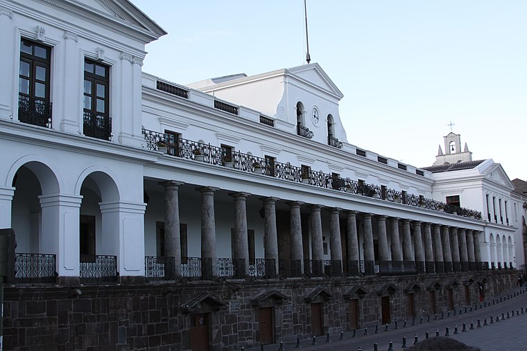 Carondelet Palace is the seat of government of the Republic of Ecuador, located in Quito. Access is by the public space known as Independence Square or Plaza Grande, around which are also the Archbishop's Palace, Municipal Palace, Hotel Plaza Grande, and Metropolitan Cathedral. Palacio de Carondelet is situated 700 metres west of Los Caldos de la Talo.
Iglesia de María Auxiliadora
Church

Photo: Ymblanter, CC BY-SA 4.0.
Iglesia de María Auxiliadora is a church, which is situated 220 metres east of Los Caldos de la Talo.
City of Quito
Protected area

Photo: Hubertl, CC BY-SA 4.0.
City of Quito is a protected area, which is situated 670 metres west of Los Caldos de la Talo.
Places in the Area
Nearby places include Quito and Chaupicruz.
Quito
 Quito, the capital of Ecuador, was founded in 1534 on the ruins of an ancient Inca city. Quito's Old City is the largest in the Americas and was one of the first UNESCO World Heritage Sites, recognized as the largest and most intact colonial city center remaining in the Americas.
Chaupicruz
Neighborhood
Chaupicruz is an electoral parish or district of Quito, the capital city of Ecuador in northwestern South America. The parish was established as a result of the October 2004 political elections when the city was divided into 19 urban electoral parishes. Chaupicruz is situated 7 km north of Los Caldos de la Talo.
Los Caldos de la Talo
- Type: Restaurant
- Category: food
- Location: Quito, Quito Canton, Pichincha, Ecuador, South America
- View on OpenStreetMap
Latitude
-0.22197° or 0° 13′ 19″ southLongitude
-78.5067° or 78° 30′ 24″ westOpen location code
67F3QFHV+68OpenStreetMap ID
node 12489866203OpenStreetMap feature
amenity=restaurant
This page is based on OpenStreetMap, Wikidata, and Wikimedia Commons.
We’d love your help improving our open data sources. Thank you for contributing.
Satellite Map
Discover Los Caldos de la Talo from above in high-definition satellite imagery.
Notable Places Nearby
Highlights include Free tour and Community Hostel.
Nearby Places
Explore places such as Las Menestras de la Don Bosco and Las Menestras del Diablito.
Ecuador: Must-Visit Destinations
Delve into Quito, Guayaquil, Chimborazo, and Cuenca.
Curious Restaurants to Discover
Uncover intriguing restaurants from every corner of the globe.
About Mapcarta. Data © OpenStreetMap contributors and available under the Open Database License". Text is available under the CC BY-SA 4.0 license, except for photos, directions, and the map. Photo: Wikimedia, CC0.