Langetrejen
Langetrejen is a locality in Lauterbrunnen, Interlaken-Oberhasli, Canton of Bern. Langetrejen is situated nearby to the locality Baawald, as well as near Wykibort.| Tap on a place to explore it |
Places of Interest
Highlights include Staubbach Falls and Trümmelbach Falls.
Staubbach Falls
Waterfall

Photo: Parpan05, CC BY-SA 3.0.
Staubbach Falls is a waterfall in Switzerland, located just west of Lauterbrunnen in the Bernese Highlands. The waterfall drops 297 metres from a hanging valley that ends in overhanging cliffs above the Weisse Lütschine.
Trümmelbach Falls
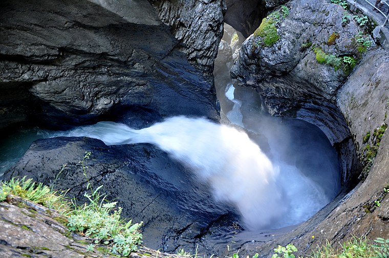
Photo: Simisa, CC BY-SA 3.0.
The Trümmelbach Falls in Bernese Oberland, Switzerland, are a series of ten glacier-fed waterfalls inside the mountain made accessible by the tunnel lift, stairs, and illumination.
Lauberhorn
Peak

Photo: Kabelleger, CC BY-SA 3.0.
The Lauberhorn is a mountain in the Bernese Alps of Switzerland, located between Wengen and Grindelwald, north of the Kleine Scheidegg. Its summit is at an elevation of 2,472 m above sea level.
Places in the Area
Nearby places include Wengen and Mürren.
Wengen

Photo: Nikolai Karaneschev, CC BY 3.0.
Wengen is an Alpine resort in the Bernese Highlands of Switzerland. It's at 1,274 m above sea level, reached by cog railway and with no vehicle access, on the route up towards the Eiger and Jungfrau.
Mürren

Photo: Thisisbossi, CC BY-SA 2.5.
Mürren is a mountain village in the Bernese Oberland of Switzerland, with a resident population of 155 but hundreds of seasonal workers and 2000 hotel guests.
Stechelberg
Village

Photo: Thisisbossi, CC BY-SA 2.5.
Stechelberg is a small village in Switzerland located at the base of the Schwarzmönch mountain in the Bernese Alps, part of the district of Lauterbrunnen. Stechelberg is situated 4½ km southwest of Langetrejen.
Langetrejen
Latitude
46.58293° or 46° 34′ 59″ northLongitude
7.92857° or 7° 55′ 43″ eastOpen location code
8FR9HWMH+5COpenStreetMap ID
node 12506946291OpenStreetMap feature
place=locality
This page is based on OpenStreetMap, Wikidata, and Wikimedia Commons.
We’d love your help improving our open data sources. Thank you for contributing.
Satellite Map
Discover Langetrejen from above in high-definition satellite imagery.
Localities in the Area
Explore places such as Baawald and Wykibort.
Notable Places Nearby
Highlights include Hasenbachfall and Kornbalm Cave.
Bernese Highlands: Must-Visit Destinations
Delve into Thun, Interlaken, Grindelwald, and Meiringen.
Curious Localities to Discover
Uncover intriguing localities from every corner of the globe.
About Mapcarta. Data © OpenStreetMap contributors and available under the Open Database License". Text is available under the CC BY-SA 4.0 license, except for photos, directions, and the map. Photo: Edwin Lee, CC BY 2.0.