Buch Alemannenstraße
Buch Alemannenstraße is in Albbruck, Waldshut, Baden-Württemberg. Buch Alemannenstraße is situated nearby to the church Kapelle Buch, as well as near the scenic viewpoint Peterskanzel.| Tap on a place to explore it |
Places of Interest Nearby
Highlights include Schneeglöckchenstandort auf Gemarkung Buch, Landkreis Waldshut and Mühlbachtal.
Schneeglöckchenstandort auf Gemarkung Buch, Landkreis Waldshut
Nature reserve

Photo: PantaRhei, CC BY-SA 4.0.
Schneeglöckchenstandort auf Gemarkung Buch, Landkreis Waldshut is a nature reserve.

Albbruck station
Railway station
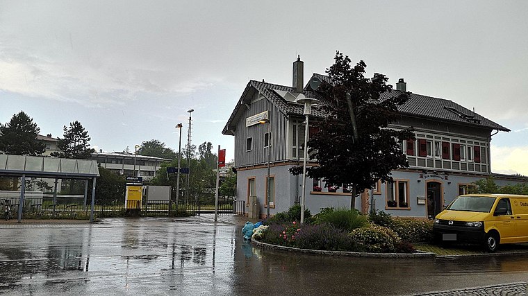 Albbruck station is a railway station in the town of Albbruck, Baden-Württemberg, Germany. The station lies on the High Rhine Railway. The train services are operated by Deutsche Bahn. Albbruck station is situated 2½ km southeast of Buch Alemannenstraße.
Places in the Area
Nearby places include Schwaderloch and Görwihl.
Schwaderloch
Village
Photo: Rauenstein, CC BY-SA 3.0.
Schwaderloch is a municipality in the district of Laufenburg in the canton of Aargau in Switzerland. Schwaderloch is situated 4 km southeast of Buch Alemannenstraße.
Görwihl
Village

Photo: Ssch, CC BY-SA 3.0.
Görwihl is a municipality in the district of Waldshut in Baden-Württemberg in Germany. Görwihl is situated 4 km northwest of Buch Alemannenstraße.
Dogern
Village

Photo: Rauenstein, CC BY-SA 3.0.
Dogern is a municipality in the district of Waldshut in Baden-Württemberg in Germany. Dogern is situated 4½ km east of Buch Alemannenstraße.
Buch Alemannenstraße
- Type: Sign
- Categories: information and tourism
- Location: Albbruck, Waldshut, Freiburg Region, Baden-Württemberg, Germany, Central Europe, Europe
- View on OpenStreetMap
Latitude
47.6126° or 47° 36′ 45″ northLongitude
8.11269° or 8° 6′ 46″ eastElevation
470 metres (1,542 feet)Operator
SchwarzwaldvereinOpen location code
8FVCJ477+23OpenStreetMap ID
node 12647091013OpenStreetMap feature
tourism=information
This page is based on OpenStreetMap, Wikidata, and Wikimedia Commons.
We’d love your help improving our open data sources. Thank you for contributing.
Satellite Map
Discover Buch Alemannenstraße from above in high-definition satellite imagery.
Notable Places Nearby
Highlights include Kapelle Buch and Peterskanzel.
Nearby Places
Explore places such as Buch Abzw. Etzwihlerstr. and Buch J. L. Gampp-Weg.
Baden-Württemberg: Must-Visit Destinations
Delve into Stuttgart, Heidelberg, Karlsruhe, and Mannheim.
Curious Places to Discover
Uncover intriguing places from every corner of the globe.
About Mapcarta. Data © OpenStreetMap contributors and available under the Open Database License". Text is available under the CC BY-SA 4.0 license, except for photos, directions, and the map. Photo: Traveler100, CC BY-SA 3.0.