Réservoir de Fontaine-André
Réservoir de Fontaine-André is a water tower in Neuchatel, Canton of Neuchâtel. Réservoir de Fontaine-André is situated nearby to the pond Étang de la Combacervey, as well as near the spring Source de Fontaine André.| Tap on a place to explore it |
Places of Interest Nearby
Highlights include Stade de la Maladière and Neuchâtel Railway Station.
Stade de la Maladière
Stadium
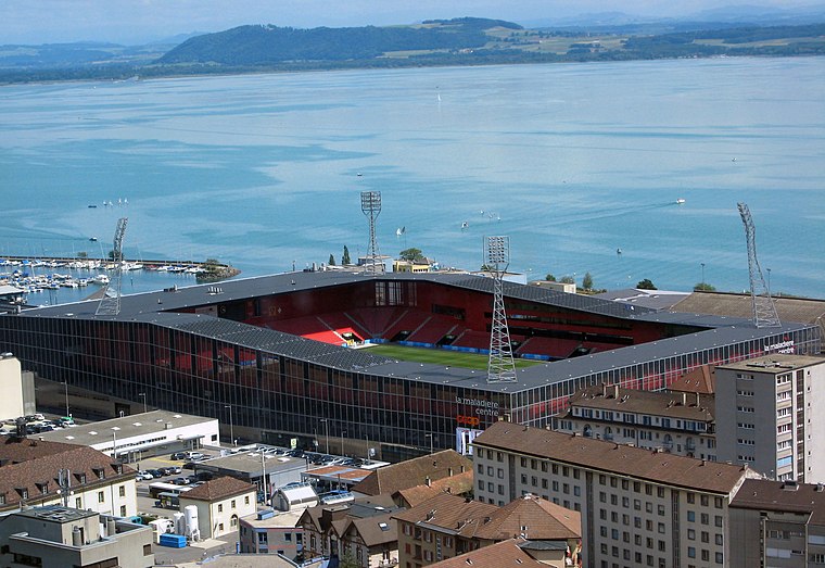 Stade de la Maladière is a multi-purpose stadium in Neuchâtel, Switzerland. It is currently used mostly for football matches and is the home ground of Neuchâtel Xamax. The stadium holds 12,000. It replaced the old Stade de la Maladière. Stade de la Maladière is situated 1½ km south of Réservoir de Fontaine-André.
Neuchâtel Railway Station
Railway station

Photo: Wikimedia, CC BY-SA 3.0.
Neuchâtel railway station serves the municipality of Neuchâtel, the capital city of the canton of Neuchâtel, Switzerland. Opened in 1857, it is owned and operated by SBB-CFF-FFS. Neuchâtel Railway Station is situated 1½ km southwest of Réservoir de Fontaine-André.
Laténium
Museum

Photo: Latenium MAK, CC BY-SA 4.0.
The Laténium is an archeology museum located in Hauterive, a suburb of Neuchâtel, Switzerland. Its name refers to the famous nearby site of La Tène which gave its name to the Second European Iron age. Laténium is situated 1½ km east of Réservoir de Fontaine-André.
Places in the Area
Nearby places include Hauterive and Fenin-Vilars-Saules.
Hauterive
Village

Photo: FOFQ, CC BY-SA 3.0.
Hauterive is a former municipality in the canton of Neuchâtel in Switzerland. On 1 January 2025 the former municipalities of Enges, Hauterive, Saint-Blaise and La Tène merged into the new municipality of Laténa.
Fenin-Vilars-Saules
Village

Photo: Imagepro, CC BY-SA 3.0.
Fenin-Vilars-Saules is a former municipality in the district of Val-de-Ruz in the canton of Neuchâtel in Switzerland. The municipalities of Boudevilliers, Cernier, Chézard-Saint-Martin, Coffrane, Dombresson, Engollon, Fenin-Vilars-Saules, Fontainemelon… Fenin-Vilars-Saules is situated 3 km northwest of Réservoir de Fontaine-André.
Saint-Blaise
Village

Photo: Zenit, CC BY-SA 3.0.
Saint-Blaise is a former municipality in the canton of Neuchâtel in Switzerland. On 1 January 2025 the former municipalities of Enges, Hauterive, Saint-Blaise and La Tène merged into the new municipality of Laténa. Saint-Blaise is situated 3 km east of Réservoir de Fontaine-André.
Réservoir de Fontaine-André
- Type: Water tower
- Category: industry
- Location: Neuchatel, Neuchâtel District, Canton of Neuchâtel, Western Switzerland, Switzerland, Central Europe, Europe
- View on OpenStreetMap
Latitude
47.00834° or 47° 0′ 30″ northLongitude
6.95071° or 6° 57′ 3″ eastOpen location code
8FV82X52+87OpenStreetMap ID
node 12791823501OpenStreetMap feature
man_made=water_tower
This page is based on OpenStreetMap, Wikidata, and Wikimedia Commons.
We’d love your help improving our open data sources. Thank you for contributing.
Satellite Map
Discover Réservoir de Fontaine-André from above in high-definition satellite imagery.
Notable Places Nearby
Highlights include Réservoir de Fontaine André and Étang de la Combacervey.
Nearby Places
Explore places such as 8 and 58.
Western Switzerland: Must-Visit Destinations
Delve into Geneva, Lausanne, Lake Geneva, and Fribourg.
Curious Water Towers to Discover
Uncover intriguing water towers from every corner of the globe.
About Mapcarta. Data © OpenStreetMap contributors and available under the Open Database License". Text is available under the CC BY-SA 4.0 license, except for photos, directions, and the map. Photo: Ypsilon from Finland, CC0.