Colegio Arquitectura Y Urbanismo
Colegio Arquitectura Y Urbanismo is a college in Rosario Department, Santa Fe which is located on Avenida Manuel Belgrano. Colegio Arquitectura Y Urbanismo is situated nearby to the government office Secretaria de Producción y Desarrollo Local, as well as near Direccion De Adultas Y Adulto Mayores.| Tap on a place to explore it |
- Opening hours: Monday—Friday 8:00 AM—1:00 PM
- Type: College
- Also known as: “Colegio de Arquitectos”
- Address: 646 Avenida Manuel Belgrano
Places of Interest Nearby
Highlights include Palacio de los Leones and Firma y Odilo Estévez Municipal Decorative Art Museum.
Palacio de los Leones
Town hall
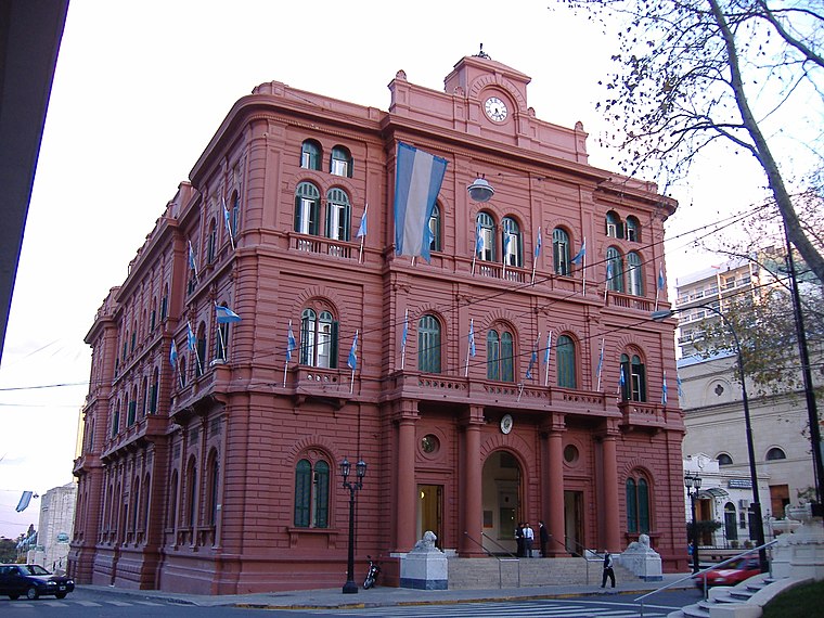
Photo: Pablo-flores, CC BY-SA 2.5.
Palacio de los Leones is the name of the main municipal building of the city of Rosario, Argentina. The Palace is the seat of the executive branch of the municipal government. Palacio de los Leones is situated 110 metres southwest of Colegio Arquitectura Y Urbanismo.
Firma y Odilo Estévez Municipal Decorative Art Museum
Museum

Photo: Fitoncho, CC BY-SA 3.0.
Firma y Odilo Estévez Municipal Decorative Art Museum is the former home of the Estévez family in Rosario, Argentina, which was donated to the Municipality of Rosario and turned into a museum. Firma y Odilo Estévez Municipal Decorative Art Museum is situated 120 metres west of Colegio Arquitectura Y Urbanismo.
Cathedral Basilica of Our Lady of the Rosary
Church

Photo: Fulviusbsas, CC BY-SA 3.0.
The Cathedral Basilica Shrine of Our Lady of the Rosary is a minor basilica and cathedral dedicated to the local Virgin of the Rosary, in the city of Rosario, province of Santa Fe, Argentina. Cathedral Basilica of Our Lady of the Rosary is situated 140 metres southwest of Colegio Arquitectura Y Urbanismo.
Places in the Area
Nearby places include Barrio Pichincha and Rosario.
Barrio Pichincha
Suburb
Pichincha is a barrio in the city of Rosario, province of Santa Fe, Argentina. It is located on the north-east part of the central area of the city, and its limits are Vera Mujica St, Cordoba St, Oroño Boulevard, and Del Valle Avenue. Barrio Pichincha is situated 3 km west of Colegio Arquitectura Y Urbanismo.
Rosario

Photo: ElGuruCesar, CC BY-SA 4.0.
Rosario is the third largest city in Argentina and the largest city in Santa Fe province, at the Paraná river. It is known for its rich architectural heritage and beautiful riverside scenery, and offers a vibrant cultural and night life.
Barrio Echesortu
Suburb
Echesortu is a barrio in Rosario, Argentina. It is unofficially known by that name even though, from the administrative point of view, its name is Remedios Escalada de San Martín. Barrio Echesortu is situated 4½ km west of Colegio Arquitectura Y Urbanismo.
Colegio Arquitectura Y Urbanismo
- Category: education
- Location: Rosario Department, Santa Fe, Pampas, Argentina, South America
- View on OpenStreetMap
Latitude
-32.9463° or 32° 56′ 47″ southLongitude
-60.63167° or 60° 37′ 54″ westBranch
Distrito 2 - RosarioOpen location code
47VX3939+F8OpenStreetMap ID
node 12804937847OpenStreetMap feature
amenity=college
This page is based on OpenStreetMap, Wikidata, and Wikimedia Commons.
We’d love your help improving our open data sources. Thank you for contributing.
Satellite Map
Discover Colegio Arquitectura Y Urbanismo from above in high-definition satellite imagery.
Notable Places Nearby
Highlights include Secretaria de Producción y Desarrollo Local and Direccion De Adultas Y Adulto Mayores.
Nearby Places
Explore places such as Growler and 8482.
Curious Places to Discover
Uncover intriguing places from every corner of the globe.
About Mapcarta. Data © OpenStreetMap contributors and available under the Open Database License". Text is available under the CC BY-SA 4.0 license, except for photos, directions, and the map. Photo: Wikimedia, CC0.