Atėnai
Atėnai is a health club in Šilutės sen., Šilutė District Municipality, Klaipėda County. Atėnai is situated nearby to the church Šilutės laisvųjų krikščionių bažnyčia, as well as near the shopping center Pamarys.| Tap on a place to explore it |
- Opening hours:
Monday—Friday: 8:00 AM—8:00 PM
Saturday: 9:00 AM—2:00 PM - Email: info@atene.lt
- Type: Health club
- Wheelchair access: no
Places of Interest Nearby
Highlights include Evangelical Lutheran Church in Šilutė and New Apostolic church in Šilutė.
Evangelical Lutheran Church in Šilutė
Church
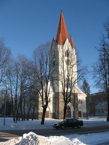 Evangelical Lutheran Church in Šilutė is situated 730 metres south of Atėnai.
New Apostolic church in Šilutė
Church

Photo: Petriukas, CC BY-SA 4.0.
New Apostolic church in Šilutė is situated 640 metres southeast of Atėnai.
Vydūnas gymnasium, Šilutė
School

Photo: Žiedas, Public domain.
Vydūnas gymnasium, Šilutė is a school, which is situated 560 metres southeast of Atėnai.
Places in the Area
Nearby places include Šilutė and Šlažai.
Šilutė
Town
 Šilutė is a city in the south of the Klaipėda County in western Lithuania. The city was part of the Klaipėda Region and ethnographic Lithuania Minor. Šilutė was the interwar capital of Šilutė County and is currently the capital of Šilutė District Municipality.

Atėnai
- Categories: recreation area and sports location
- Location: Šilutės sen., Šilutė District Municipality, Klaipėda County, Lithuania, Baltic states, Europe
- View on OpenStreetMap
Latitude
55.34913° or 55° 20′ 57″ northLongitude
21.46455° or 21° 27′ 52″ eastOpen location code
9G738FX7+MROpenStreetMap ID
node 12869303009OpenStreetMap feature
leisure=fitness_centreOpenStreetMap attribute
wheelchair=no
This page is based on OpenStreetMap, Wikidata, and Wikimedia Commons.
We’d love your help improving our open data sources. Thank you for contributing.
Satellite Map
Discover Atėnai from above in high-definition satellite imagery.
Places with the Same Name
Discover other places named “Atėnai”.
Notable Places Nearby
Highlights include Šilutės laisvųjų krikščionių bažnyčia and Pamarys.
Nearby Places
Explore places such as Auto malūnas and Noriu kalbėti.
Lithuania: Must-Visit Destinations
Delve into Vilnius, Kaunas, Klaipėda, and Šiauliai.
Curious Health Clubs to Discover
Uncover intriguing health clubs from every corner of the globe.
About Mapcarta. Data © OpenStreetMap contributors and available under the Open Database License". Text is available under the CC BY-SA 4.0 license, except for photos, directions, and the map. Photo: Lestath, CC BY-SA 3.0.