Monchique
Monchique is a tram stop in Lordelo do Ouro e Massarelos, Porto. Monchique is situated nearby to the building Casa do Cais Novo, as well as near the ruins Fábrica de Encerados da Restauração.| Tap on a place to explore it |
Places of Interest Nearby
Highlights include Super Bock Arena and King Charles Albert chapel.
Super Bock Arena
Stadium
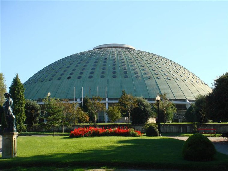
Photo: Wikimedia, Public domain.
The Super Bock Arena is a cultural and sports arena in Porto, Portugal. Super Bock Arena is situated 250 metres northeast of Monchique.
King Charles Albert chapel
Church

Photo: -wuppertaler, CC BY-SA 4.0.
King Charles Albert chapel is a church, which is situated 140 metres north of Monchique.
Gardens of the Palácio de Cristal
Park

Photo: JP Bennett, CC BY 2.0.
Gardens of the Palácio de Cristal is a park.
Places in the Area
Nearby places include Massarelos and Vitória.
Massarelos
Neighborhood
 Massarelos is a former civil parish in the municipality of Porto, Portugal. In 2013, the parish merged into the new parish Lordelo do Ouro e Massarelos.
Vitória
Neighborhood

Photo: Aoamen, CC BY-SA 3.0.
Vitória is a former civil parish in the municipality of Porto, Portugal. In 2013, the parish merged into the new parish Cedofeita, Santo Ildefonso, Sé, Miragaia, São Nicolau e Vitória.
São Nicolau
Neighborhood

Photo: Wikimedia, CC BY-SA 3.0.
São Nicolau is a former civil parish in the municipality of Porto, Portugal. In 2013, the parish merged into the new parish Cedofeita, Santo Ildefonso, Sé, Miragaia, São Nicolau e Vitória. The population in 2011 was 1,906, in an area of 0.25 km2.
Monchique
- Type: Tram stop
- Wheelchair access: no
- Categories: railway stop, transport stop, and transportation
- Location: Lordelo do Ouro e Massarelos, Porto, Porto District, Portugal, Iberia, Europe
- View on OpenStreetMap
Latitude
41.14478° or 41° 8′ 41″ northLongitude
-8.62728° or 8° 37′ 38″ westNetwork
AndanteOpen location code
8CHH49VF+W3OpenStreetMap ID
node 1296455429OpenStreetMap feature
public_transport=stop_positionOpenStreetMap feature
railway=tram_stopOpenStreetMap attribute
wheelchair=no
This page is based on OpenStreetMap, Wikidata, and Wikimedia Commons.
We’d love your help improving our open data sources. Thank you for contributing.
Satellite Map
Discover Monchique from above in high-definition satellite imagery.
Places with the Same Name
Discover other places named “Monchique”.
Notable Places Nearby
Highlights include Casa do Cais Novo and Cais Novo.
Nearby Places
Explore places such as Monchique and Mural da Restauração.
Portugal: Must-Visit Destinations
Delve into Lisbon, Caldas da Rainha, Coimbra, and Braga.
Curious Tram Stops to Discover
Uncover intriguing tram stops from every corner of the globe.
About Mapcarta. Data © OpenStreetMap contributors and available under the Open Database License". Text is available under the CC BY-SA 4.0 license, except for photos, directions, and the map. Photo: Olegivvit, CC BY 2.5.