Les petits glaçons
Les petits glaçons is an ice cream parlor in Clermont-Ferrand, Puy-de-Dôme, Auvergne-Rhône-Alpes which is located on Place Saint-Pierre. Les petits glaçons is situated nearby to the marketplace Halle Gourmande Saint-Pierre, as well as near Place Saint-Pierre.| Tap on a place to explore it |
- Opening hours:
Tuesday—Friday: 1:00 PM—7:00 PM
Saturday: 10:30 AM—7:00 PM - Email: contact@lespetitsglacons.com
- Type: Ice cream parlor
- Address: Place Saint-Pierre, 63000
Places of Interest Nearby
Highlights include Hôtel de Fontfreyde and Clermont-Ferrand Cathedral.

Clermont-Ferrand Cathedral
Church
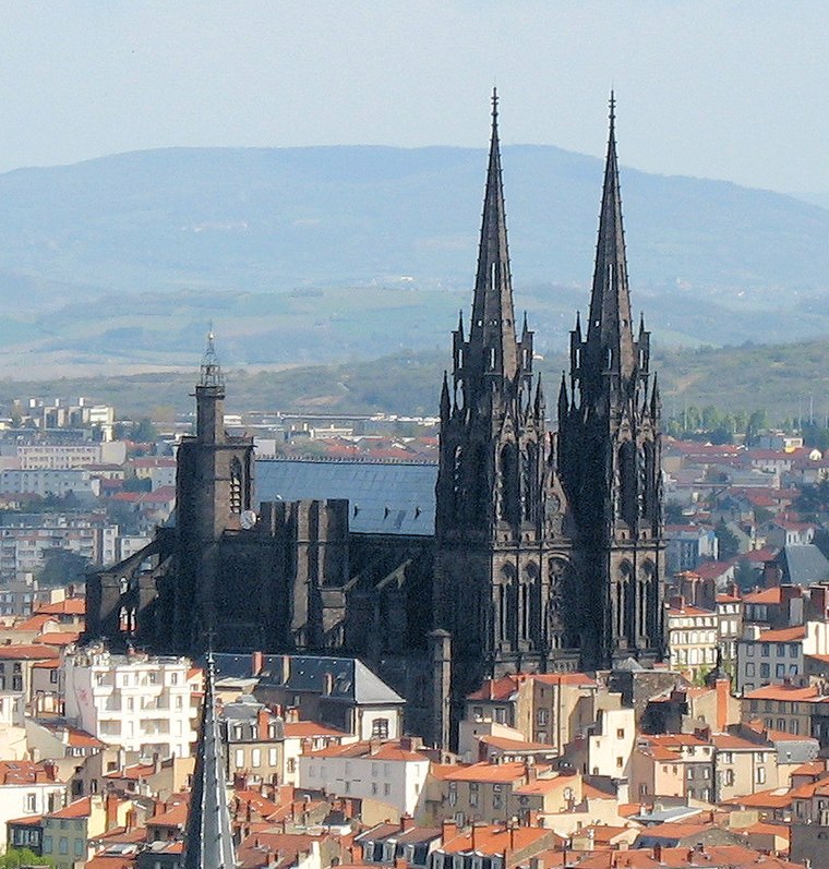
Photo: Fabien1309, CC BY-SA 2.0 fr.
Clermont-Ferrand Cathedral, or the Cathedral of Our Lady of the Assumption of Clermont-Ferrand, is a Gothic cathedral and French national monument located in the city of Clermont-Ferrand in the Auvergne. Clermont-Ferrand Cathedral is situated 230 metres east of Les petits glaçons.

Places in the Area
Nearby places include Chamalières and Herbet.
Chamalières
Town

Photo: Alexandre.chassignon, CC BY-SA 3.0.
Chamalières is a commune in the Puy-de-Dôme department, Auvergne-Rhône-Alpes, central France. With 17,276 inhabitants, Chamalières is the fourth-largest town in the department.

Beaumont
Town
 Beaumont is a commune in the Puy-de-Dôme department in Auvergne-Rhône-Alpes in central France. The commune lies to the south of the dormant volcano, the Puy-de-Dôme which is clearly visible, including the telecommunication antennas that sit on its top. Beaumont is situated 3 km south of Les petits glaçons.
Les petits glaçons
- Category: food
- Location: Clermont-Ferrand, Arrondissement of Clermont-Ferrand, Puy-de-Dôme, Auvergne, Auvergne-Rhône-Alpes, France, Europe
- View on OpenStreetMap
Latitude
45.77909° or 45° 46′ 45″ northLongitude
3.08293° or 3° 4′ 59″ eastOpen location code
8FQ5Q3HM+J5OpenStreetMap ID
node 12966463201OpenStreetMap feature
amenity=ice_cream
This page is based on OpenStreetMap, Wikidata, and Wikimedia Commons.
We’d love your help improving our open data sources. Thank you for contributing.
Satellite Map
Discover Les petits glaçons from above in high-definition satellite imagery.
Notable Places Nearby
Highlights include Halle Gourmande Saint-Pierre and Théâtre des 3 Raisins.
Nearby Places
Explore places such as Les petits glaçons and Planète Tel +.
Auvergne: Must-Visit Destinations
Delve into Vichy, Aurillac, Le Puy-en-Velay, and Mont Dore.
Curious Ice Cream Parlors to Discover
Uncover intriguing ice cream parlors from every corner of the globe.
About Mapcarta. Data © OpenStreetMap contributors and available under the Open Database License". Text is available under the CC BY-SA 4.0 license, except for photos, directions, and the map. Photo: Wikimedia, CC0.