Il-Marsa - Pakket
Il-Marsa - Pakket is a bus stop in Il-Marsa, Malta. Il-Marsa - Pakket is situated nearby to Turkish Cemetery, as well as near The Addolorata Chapel.| Tap on a place to explore it |
Places of Interest Nearby
Highlights include Ħal Saflieni Hypogeum and Ħal Tarxien Temples.
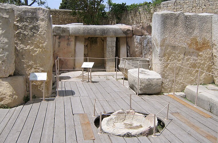
Ħal Saflieni Hypogeum
Museum

Photo: Wikimedia, CC BY-SA 3.0.
The Hypogeum of Ħal Saflieni is a Neolithic subterranean structure dating to the Saflieni phase in Maltese prehistory, located in Paola, Malta. It is often simply referred to as the Hypogeum, literally meaning "underground" in Greek. Ħal Saflieni Hypogeum is situated 1 km east of Il-Marsa - Pakket.
Ħal Tarxien Temples
Protected area
 The Ħal Tarxien Prehistoric Complex is an archaeological complex in Tarxien, within the Port region of Malta. They date to approximately 3400 BC. The site was accepted as a UNESCO World Heritage Site in 1992 along with the other Megalithic temples on the island of Malta. Ħal Tarxien Temples is situated 1½ km east of Il-Marsa - Pakket.
Addolorata Cemetery
Cemetery

Photo: Wikimedia, CC BY-SA 3.0.
The Santa Maria Addolorata Cemetery, often known simply as the Addolorata Cemetery, is a state-owned, Neo-Gothic cemetery located in Paola, Malta. It is a multi-faith cemetery, but predominantly characterized by Catholic burials. Addolorata Cemetery is situated 510 metres east of Il-Marsa - Pakket.
Places in the Area
Nearby places include Paola and Santa Luċija.
Paola
Town
Photo: Sudika, CC BY-SA 3.0.
Paola is a town in the Port Region of Malta, with 8,706 inhabitants as of 2019. The town is a commercial centre in the Southern Harbour area of Malta, about 5 km from the capital Valletta, contiguous to Tarxien and Fgura, with which it forms a single urban area.
Santa Luċija
Village

Photo: Wykebjs, Public domain.
Santa Luċija is a village in the Southern Region of Malta, with a population of 3,623 as of January 2022. It is one of the modern towns developed in Malta during the 20th century.
Luqa
Village

Photo: Wykebjs, Public domain.
Luqa is a town located in the Southern Region of Malta, 4.3 km away from the capital Valletta. With a population of 5,945 as of March 2014, it is a small but densely populated settlement which is typical of Malta's older towns and villages.
Il-Marsa - Pakket
- Type: Bus stop
- Category: transportation
- Location: Il-Marsa, Malta, Europe
- View on OpenStreetMap
Latitude
35.86962° or 35° 52′ 11″ northLongitude
14.49501° or 14° 29′ 42″ eastOperator
Malta Public TransportNetwork
Malta Public TransportOpen location code
8F7PVF9W+R2OpenStreetMap ID
node 13095995675OpenStreetMap feature
highway=bus_stopOpenStreetMap feature
public_transport=platform
This page is based on OpenStreetMap, Wikidata, and Wikimedia Commons.
We’d love your help improving our open data sources. Thank you for contributing.
Satellite Map
Discover Il-Marsa - Pakket from above in high-definition satellite imagery.
Notable Places Nearby
Highlights include Turkish Cemetery and The Addolorata Chapel.
Nearby Places
Explore places such as Il-Marsa - Pakket and Il-Marsa - Dajsa.
Malta: Must-Visit Destinations
Delve into Valletta, Mdina, Sliema, and Victoria.
Curious Bus Stops to Discover
Uncover intriguing bus stops from every corner of the globe.
About Mapcarta. Data © OpenStreetMap contributors and available under the Open Database License". Text is available under the CC BY-SA 4.0 license, except for photos, directions, and the map. Photo: Dirk.heldmaier, CC BY-SA 3.0.